
")
In the West End, the Confederation Line LRT will eventually extend to Lincoln Fields, then along Pinecrest Creek (where the transitway is) and it will split into two directions from a point north of the Queensway.
One leg will carry on to Algonquin College. The other leg vers westward under a city park and emerges from its underground tunnel between the Queensway and the west end bus garage on Queensview Drive. The in-an-open-cut Queensview Station ( much like Westboro and Tunney’s Stations) will replace the lawn directly in front of The Brick.
Directly opposite The Brick is The Ottawa Citizen plant, and a bit further west, IKEA.

Ground level access from Queensview neighbourhood to the Station will be via a walk in pathway between The Brick and the OC Transpo Garage. And also via the new multi user path coming from the Pinecrest Corridor.
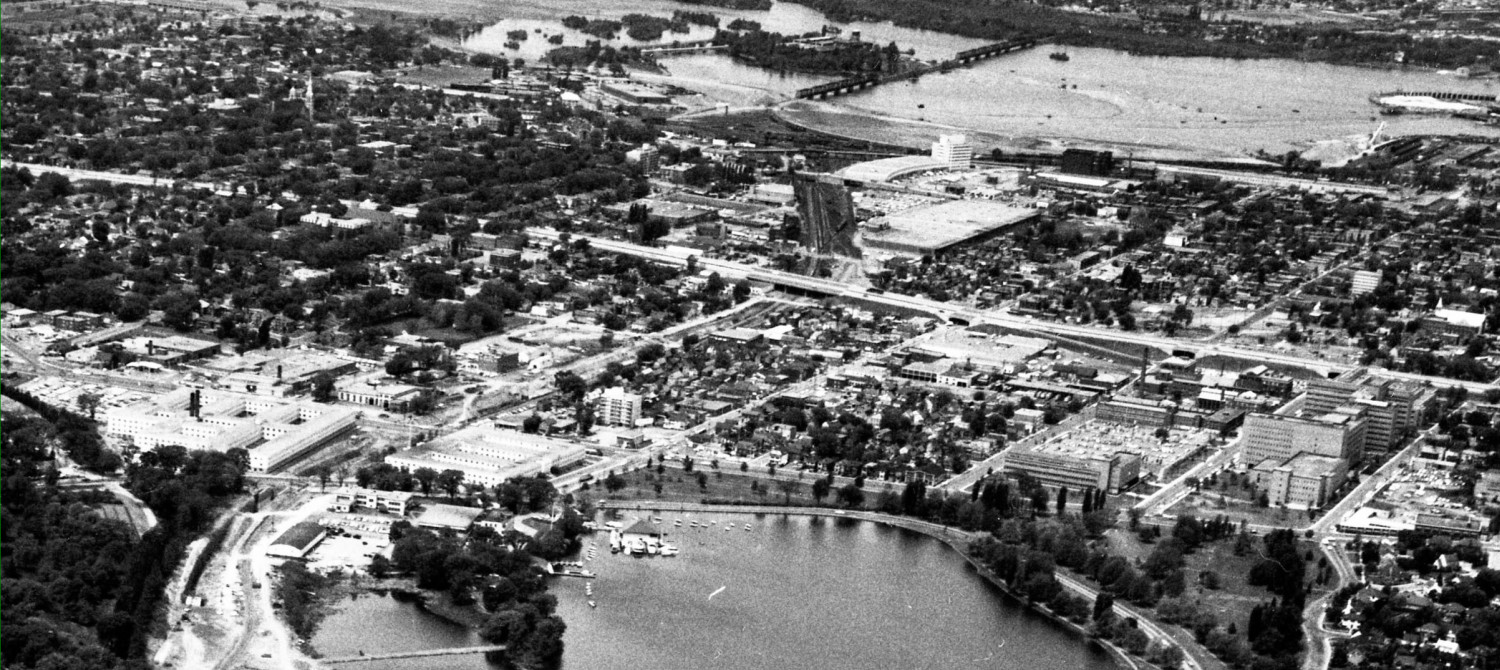
The proposed Queensview Crossing pedestrian and cyclist bridge will run from the Queensview Station directly across the freeway to land approximately between the orange pin and the parked white bus on the above aerial view. This isn’t as long a crossing of the freeway as the Coventry bridge does, but I expect the bridge will be roughly the same look and feel.

A long inclined ramp will come up from the east side of The Brick property, and stairs and elevators will connect the new Bridge down to ground level and then down into the cut where the centre-platform station will be, directly in front of The Brick’s front door.
On the south side of the freeway, users of the Queensview Bridge south end stairs will have a close-up view of the Citizen loading docks:

or, if they take the long inclined ramp down to street level, they will arrive on Baxter Road about here:

That’s the Citizen parking lot on the left; IKEA is in the distance to the right, and Iris Street is somewhere ahead.
Presumably sidewalks out to Iris Street will be glued to the Baxter Road curb to make access to the bridge easier. No word if IKEA will build walkways into its store. Hopefully it won’t be a walkway following the circuitous road near the Queensway; I’d rather a more direct one through their parking garage so I won’t get wet or sunburned in the Million Acre Parking Lot. Might be a lot safer too.
Courtesy of Google, here’s an aerial view of the location, looking south. The Queensview Ped Bridge will cross the freeway between the Baxter Orange Dot and the white bus parked in the bottom left corner. The long ramp down brings one out on Baxter just south of the 417 road marker on the picture. Notice, BTW, that IKEA has a heat-reflecting white roof in contrast to the older industrial and commercial buildings in the Queensview area.

Here’s the same aerial view onto which I have attempted to draw the new LRT alignment with pink arrows, and show the ramps and Queensview Ped bridge with dotted splots.

(My kindergarten teacher knew even then that I should do better …)
Unlike the Coventry Station vicinity, there is no intensification plan for the area. Probably because there is less undeveloped land. However, with improved accessibility via transit plus Queensway exposure, we can expect the industrial properties on Queensview (including OC Transpo’s garage) to be redeveloped starting around 2023. By that point, a number of the buildings will be at the end of their life span. IKEA also has lots of potential for office buildings and more intensive development on its site. Expect new structures to be built above parking decks, much like IKEA is now.
The residential areas north and south of the Queensway corridor will also come under intensive redevelopment and intensification pressure. These are neighbourhoods of affordable small-ish (by today’s standards) 1950’s, 60’s and 70’s homes on large lots. The city is almost ready to permit severing corner lots to fit in additional houses; there will be more of the usual Mediterranean style monster homes with multiple garage doors, and probably those modern shoe box infills made of corrugated metal. Tell your friends to buy there now in expectation of rapid price increases.
There are no City claims of a grand Transit-Oriented-Development plan for the area. Expect to see gradual, incremental change over the coming decades. It will be up to community groups and interest groups to lobby for improved infrastructure for people who walk or cycle.There is certainly abundant opportunity for such improvements.
The new Queensview Bridge in particular makes cycling more viable as it creates an alternative crossing of the freeway, allowing people who ride to avoid the Pinecrest Interchange-from-Hell (although “fixes” are on the schedule for the 2020’s for there too, when the Pinecrest LRT Station is built).
(Part i of this series looked at the Coventry crossing now. Part ii looked at the planned bigger-suburban style intensification plans and laments missed opportunities. Part iii shifts to the Coventry’s cousin bridge at Queensview. ) Use the back arrow below to go back to those articles.
Hi Eric – the City reports that the plan (as currently drafted) also includes pedestrian/cycling improvements to the Pinecrest bridge at the same time as the LRT going in. And there will be access to the Pinecrest LRT station from both east and west sides of Pinecrest, so peds/bikes will have the option to go under the bridge entirely, instead of navigating the terrible intersections. Promising!
stay tuned as the next few articles review each of the WLRT stations, working from westboro to bayshore …