
 Tunney’s Pasture")
Tunney’s Pasture is the interm western end of the initial LRT system. At Tunney’s, riders will transfer from bus rapid transit on the transitway to LRT to go through the downtown and then on to Blair Road in the East.
Tunney’s is the second largest employment node in the City, and will triple in size over the next few decades. At some point the LRT service will extend west of Tunney’s to Lincoln Fields and then out to College Square.
The new LRT station will replace the existing bus station at Tunney’s, down in the cut. The train track will extend a few meters west of the station, for storing equipment and turning train sets around. On the north side of the cut, where there is presently a lawn, there will be an oval loop bus depot. On the south side, along Scott, will be bus stops for local buses and the few express buses continuing along Scott to Bayview, LeBreton, and thence to Gatineau.
Here’s what it will look like, when viewed from the transitway:

Above: Scott Street is on the right; Tunneys and the new bus-transfer station to the left. Set in the same cut, the station reuses the same retaining walls as the current bus station. The City will replace the transitway asphalt road surface with rails; under the road there are two big box sewers already there.
What follows is the planning rationale for the station, how the station functions, and details for the keeners.

Above: the arrows show major organizing features for the site. They are maintaining long vistas and views along Scott, and along Holland towards the Brooke Claxton Building. (I confess to mixed emotions about the centre boulevard there — why not develop it for a row of condos to add some “mixed use” and life to a site that goes dead after 4pm? Brooke Claxton, formerly known as Judy’s Tower (after Judy LaMarsh, the cabinet minister responsible) isn’t exactly Peace-Tower-worthy of a view, IMO).
Towards the left, notice how the LRT tracks (in red) terminate just west of the station, and the dotted line shows the buses taking a new ramp up out of the cut to a ground level turning oval and station. The pinkish north-south line shows an extension to Goldenrod Avenue, either a bridge or a filled embankment. This is a new road link that isn’t there now.
The next slide shows key circulation paths around the site:

There are two dotted circles shown. the inner one is the 300m or 4 minute walk zone; and the outer circle is the 600m or 8 minute walk zone (your walking path may differ and take longer if you chose to walk around the buildings).
Look for Scott Street on the map (light blue line running left-right). On the same axis is a yellow dashed line indicating on-street painted bike lane(s). Immediately above the dashed line is a dark blue solid line, indicating the multi-user path, or MUP. In the 1970’s, the City built the MUP that is there now along Scott and it falls far short of today’s design standards. The MUP will be rebuilt (eventually?) as a 4m wide path. Note also how bike lanes travel up to the turning circle in front of the Claxton Building (replacing on-street parking?), and then over to Parkdale, further east on Burnside to the new traffic roundabout there; and up Parkdale to join onto the Ottawa River cycle paths. Who is going to mark or build these, and when, is not specified. Certainly the access for peds and cyclists from Parkdale onto the River paths is appallingly bad and dangerous today. But at least the larger site plan considers these access routes.
Less well developed is the walk in from the neighborhoods to the south. Do they expect everyone to behave like motorists, and stick to the arterials like Holland? If people filter towards the station via the residential streets, how easy will it be to cross Scott mid-block?
While you have to have remarkable eyes to pick it out on the small pictures included here, the key to the slide shows that the sidewalks in Tunney’s are also labelled as ‘cow paths’. Yup. Seriously. Surely this is not an editorial comment on the inhabitants of the cubicle farms in the Pasture…
![]()
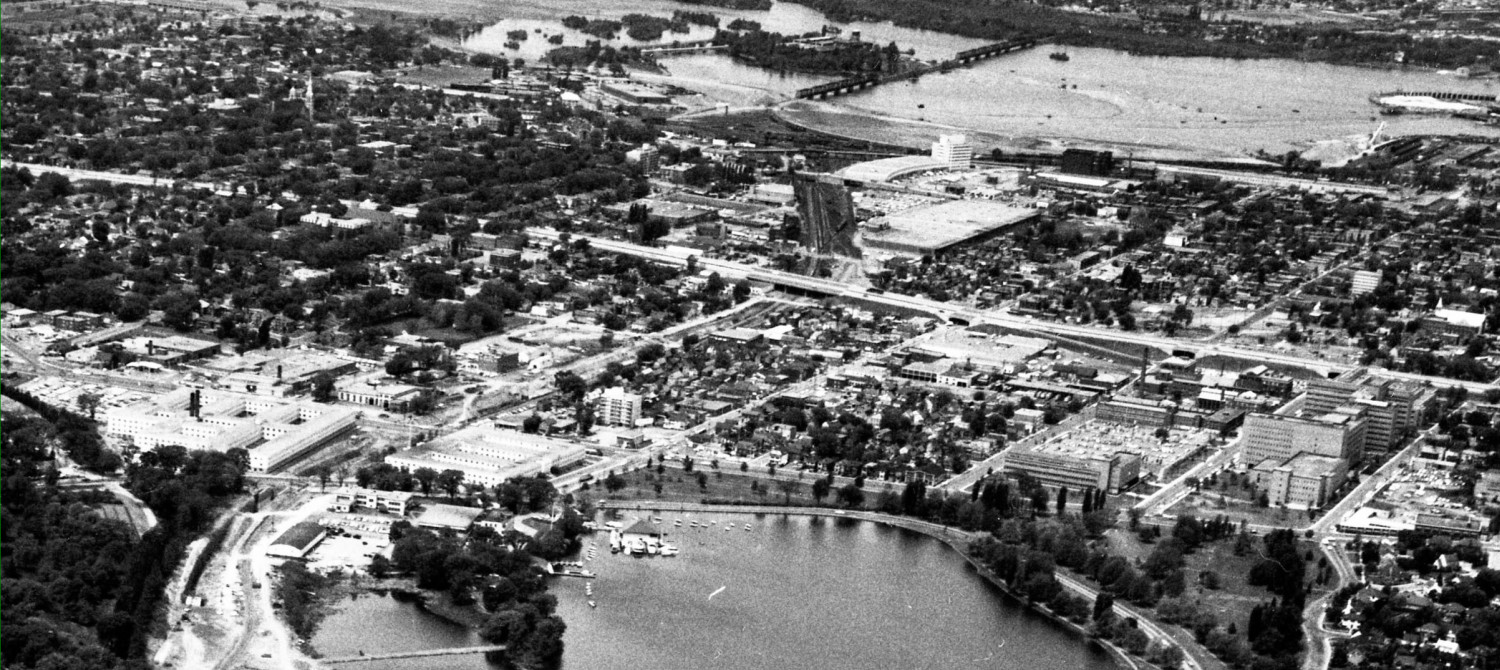
Next up is an air photo of the overall site:

Above: the red line is the new LRT track, extending a bit west of the station shown in yellow. The first phase station is west of the Holland Avenue overpass; when fully built out it will extend under the Holland Avenue overpass.
Zooming in closer:

Notice a couple of things in the air photo above. First, the existing pedestrian overpass with the bright red roof, a signature element of the old transitway system. This overpass will be doubled in width. Then notice the buses using the overpass just northwest (left of) Huron Avenue to access the north side of the station. The City will close this overpass to buses, and convert it into a major pedestrian element of the new LRT station. Notice the turning loop towards the left, where buses get in and out of the transitway cut. A new angled road to get the buses up and to the new station on the north side will be near here, and the City will extend Goldenrod over the transitway cut (either with an earth fill or bridge) to join Scott Street.
To see all those elements in place, check out the next drawing:

The station itself is in the cut; there are two entry buildings or mezannines on the Scott Street level. One is on a widened-pedestrian overpass close to Holland Avenue. The darker yellow part is the “within station” part where you take the escalator down to the LRT platforms where the existing bus stop waiting areas are.
A bit further west (to the left) the former bus bridge that took buses from Scott over the cut to the service roads on the north side, the City has enclosed making an entry hall accessing the escalators and elevators to the platforms.
Even further to the left will be the new filled-in bit of the transitway trench, upon which the City will build an extension of Goldenrod Avenue to let the buses over to the north side of the cut, where there will be an oval track for storing buses. The filled-in bit of the cut will have to be removed or replaced with a bridge once the LRT extends further west, if the oval is to continue to be used as local bus transit station (which is surely a better location than on Scott Street itself, if buses are to “time stop” there).
Notice that OC Transpo will store buses on Yarrow, on the oval, and on the north side of Scott. There appears to be two bus stop areas on the north side of Scott, one at each pedestrian plaza entrance to the LRT station. It is possible to walk across the cut on either pedestrian bridge without going indoors. Of course, if you are not simply transferring bus to LRT, or going into work at Tunney’s, and using this as your local walkin transit station, then you face the same situation as now, which is to say nothing seems to have been planned for neighborhood walkins.
Direct your attention to the far right, where the existing Scott Street MUP (aka bicycle path) is identified as being rebuilt (by who? when?) as a 4m path. This is great news. Hopefully the City can build a proper cross walk / cross bike at the intersection. But then notice how the bike traffic is directed to pass between the station entrances and Scott Street. While this can be done, safely, with coloured pavement textures and other clues to pedestrians, the path is labelled as being only 1.4m wide. Hmm. This obeys Council’s motion of Dec 2009 to preserve the BikeWest right of way, but only just.
Also notice that at the top, on Yarrow, close to Tunney’s Pasture Drive (aka Holland) there is a cute kiss and ride lot. I really doubt if it will get any use, but at least it is so minor a feature as to be inoffensive. Perhaps it will be pressed into better use for bus storage.
In previous versions of the Tunney’s bus turnaround area, the bus passenger platforms were in the centre of the oval (like at Hurdman). Passengers could descend down to track level from the building in the centre of the oval, walk through a short tunnel, directly onto the platforms. This new scheme is cheaper more economical with our transit dollars, as passengers will walk around the oval at surface level.
So where exactly is the station building? In the illustration below, the blue dotted line shows the extent of the overhead roof area. All the area within the dotted trapezoid will be under the roof, but not indoors.

The red triangles show the main pedestrian entry points to the station area. Trains entering the station can come in on either track, but must leave on the same track as there is no crossover west of the station. So passengers coming into the station might find the next train to the downtown on either track. Since this is not a centre platform station, there will have to be some sort of signalling system to tell customers which track to head for.
Next a closer-up look at the area under the station roof:
Remember that the building roof is like a saddle, it sags to the middle. In the middle, it will be an open skylight between the two train tracks below. Rain water will run off the roofs into the space below. The City is proposing to build a planter box between the tracks, watered by the drip and lit by the open sky directly above.
The generous roofed over area on both sides of the station, in the middle “waist” area, the City has designed for rain-sheltered bike parking. This parking area appears very generous and will be a boon for Westboro cyclists. Well done City of Ottawa!
A little bit worrisome to me are the two elevators, which are somewhat isolated at the far west end of the station. It also appears there are only two escalators, at the western end, with stairs at the eastern end where the current pedestrian overpass is. This is more apparent when viewing the platform level drawing below:

See how the elevators are tucked away at the left end? If I was a smoker sneaking a smoke, or buying my Indian smokes for the day at work, I’d do the transaction at the far west end of the platform… There is also only one elevator for each platform; two elevators are required in case one breaks down. Are they planning to roll wheelchairs and strollers across the tracks to the opposite platform if one elevator breaks? Will civil servants with walkers be able to cross the tracks fast enough before being run over by the next LRT?
If you have really sharp eyes, you will have noticed the two escalators are marked down to the south side platform for trips into the downtown; and up on the north side platform for trips continuing west. I don’t know how accurate this is, or how they intend to move the train from the north platform to the south one when there is no crossover track west of the platforms…
Clearly, to judge by the location of the wider mezzanine areas and escalators, they are expecting most use to focus on the western end of the platform. This will be a very much at one end of the train, and even futher when the platform is extended under Holland Avenue overpass at ultimate build-out. I wonder if people will behave as the planners expect. Or maybe the planners don’t expect this to actually happen, as they drew their 4 and 8 minute walk circles centred on the Holland Avenue end of the station!
The next drawing shows the station profile, as seen from the end:

The station roof soars 16′ -24′ above the sidewalk at street level; 33′ above the track platform in the cut below. Even though located in a hole, this station should be very pleasant.
Here is a blow up of the station, showing the roof area, the mezzanine levels, and the platforms, with red arrows showing the main pedestrian flows:

Tomorrow: Bayview Station
I know I (and others) have said this before, but I think the city is really REALLY missing an opportunity to make our transit system more of an urban transit system while we’re rebuilding the spine anyway. I think that this is our chance to move TP station east to sit between Holland and Parkdale, so that there’s a safe and significant crosswalk at both ends of the platform, with multiple important uses in both directions. I think this would better balance the demand/flow at both ends of the platform and bring transit closer to the intensification (ongoing and opportunity) on Parkdale and to the Parkdale Market. If necessary, there could be separate entrances on both sides of Holland/TPDrvwy to balance walk on/off traffic with the suburban bus transferers (of course this “problem” is most easily solved by building the system further west to the existing transfer stations from the get go, nullifying the need for a tempo transfer station defiling some of the most valuable empty real estate in the city).
This would shift also increase the distance between TP and Westboro stations, and increase the rationale for a new station at Island Park to better serve the Mosque, Ashcroftland and the currently empty western sections of Tunney’s Pasture (which can’t stay empty forever being right beside the now $1million 50×100 lots of Champlain Park).
but then again, as Ken Gray’s blog shows, everyone’s an expert second guessing this project.
The difficulty with moving the station east of Holland is handling the buses coming from the Transitway to the west.
Yet again, we’re allowing an unhealthy obsession with buses to drive station design. The system should be built from at least Lincoln Fields to Blair on day 1. Were it to do so, moving the station from Tunney’s Pasture to Holland-Parkdale would be quite possible because the design constraint imposed by the need to accommodate Transitway buses would be removed.
Eric, you’re being way too productive and knowledgeable….that’s not how this city operates.
Overall, the design is suitable for what is essentially a temporary station (until the westward extension is completed). The one major concern I would have is that the design doesn’t seem to consider the clustering of passengers transferring from Transitway buses who will all use the western escalators/staircases (given that is the shortest distance from the bus oval) and all wait at the bottom of those escalators/staircases while waiting for trains. Why not extend the bus oval slightly eastwards so that buses would stop in between two sets of escalators/staircases so both will be used?
kcyow: You know, I missed that! The emphasis on the west end of the platform is due to the transfer facility being located there. I focussed on the walkins and access to work use of the station. My views still apply once the system is extended west, but until then the west end of the station will get a lot of use. It is up to the local councillor and community associations to ensure the station is accessible from the residential community to the south.
I agree that the Westward orientation of the station poses a number of problems, but I also don’t see how they can move it to the logical spot between Holland and Parkdale (although I do love the idea of an Island Park Station for PURELY selfish reasons, as that would be 150m from my door). The Transitway transfer passengers need to be the priority for the first X years. But that just exacerbates the “neighbourhood connection” problem. You notice they don’t include a projected percentage of traffic from all directions on this station. That’s because a significant chunk will be coming from Wellington West (West of the station), and they haven’t figured out how to get pedestrians across Scott Street.
Note that the West end of the station is a full two blocks from Holland. I’m thinking we in the neighbourhood need to push for a stoplight and proper crosswalk at Smirle – which will also be the new turning point for buses from Scott heading across the new connection into Tunney’s.
@James
I think James makes a very good suggestion. moving the station to the other side of Holland makes sense to me.
I would also like there to be a couple of retail opportunities at the exits to the building designed into this building.
Yes to properly integrated retail – at least a small kiosk to allow bus ticket sales.
And coffee. Must have coffee to keep the public service running.
A licensed coffee shop, for those getting off work.
No, we’ve already got too many Royal Oaks…
As a resident of Wellington West I use the existing station often and walk, bike, and drive in this neighborhood.
The plan is pretty good and is a good compromise between cost and improving the site. The use of the existing rock cut will surely save ti e and money, but does restrict the overall plan somewhat. The existing station is a claustrophobic eyesore and the structures are unsightly and when crowded with commuters, difficult to navigate.
The lack of a second pedestrian crossing farther West on Scott is problematic – the next intersection at Western is almost a kilometer away forcing people to cross Scott on a wing and prayer against cars often traveling in excess of 80kmh. By removing the existing surface bus station the snarl at the holland intersection will be relieved: the current mix of cars exiting Tunneys plus buses and pedestrians crossing is a mess. In addition, the road surface of Scott in this area is in poor condition.
I agree that there is a need for some retail in the station no matter how small the retail outlet is. My main concern is the design of the roof of the station. To me the roof should convex rather than concave. While the idea of having runoff water watering the plants below is a novel idea one has to think about the snow load and sub-zero temperatures that are prevalent 4 months of the year. If water drains off the roof to an unheated area below then it may freeze and backup the drainage system in the winter. This will increase the load on the roof requiring it to be reinforced more. I am not a structural engineer but I would think in our climate the shape of the roof is not advisable.
Has any thought been given to having the BRT buses drop off passengers 1) on the same level as the LRT and 2) inside the “fare-paid” zone.
This would make transfers much quicker and easier, and easy transfers are a key part of making Ottawa’s new hybrid BRT-LRT commuter system work.
Even if they don’t do this at the temporary Tunney’s transfer station, I hope they do it for the more permanent Blair transfer station.
I recall that between the first and second conceptual designs (months or years ago), they added a level crossing at the platform level at the West end of the platform, between the loading area and the two spots for spare trains (i.e. trains would only cross it very occasionally). Maybe it was removed in this latest version, but if it’s still there, that would alleviate various problems you identify, including only one elevator per side, up/down escalators only on one side each, and communicating to passengers which side their train is on. On the last point, it would also provide another reason why the elevators and access is focused on the west side: so passengers can easily switch sides if they came down onto the wrong platform.
The point by “Commuter” above is a very interesting one, to put the buses in the fare-paid zone to facilitate transfers. The cynic in me things that they never even considered it, though potential downsides include: require extra staff to monitor/support the extra entrance, entry to bus area restricted to one or more entrances, more ugly fences/walls/barriers.