
 LeBreton")
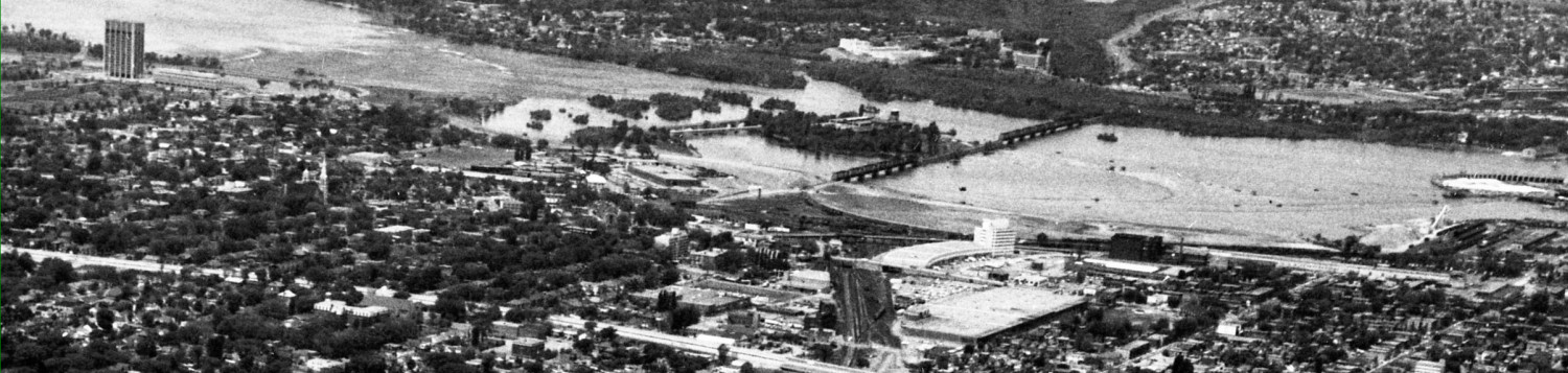
There is currently a bus transitway station at LeBreton Flats. The proposed LRT station is essentially at the same location, except it extends further west under Booth Street and is a few feet south of the current station, allowing room for landscaping and breathing space between it and the aqueduct.

On the aerial photo above, note also the pedestrian crossing of the aqueduct off to the left side of the picture, this is the old Broad Street right of way and ped bridge.

The site analysis drawing, above, shows the proximity of the current LeBreton residential neighborhood. Blue arrows show view planes, but both are rather curiously located. While there may be a view north along Booth, the midblock view of the War Museum is only temporary — maybe 20 years or so until Claridge builds more condos. The view plane from the Ottawa River Commuter Expressway / new Wellington has already been established and it is along the Wellington axis, not nearly as far south as shown. It makes me wonder if these view lines have any real meaning for the stations …
There are five stone arch bridges across the aqueduct. The one that Booth currently crosses will be saved, and reused as a pedestrian bridge at the station platform level, while Booth itself will be elevated about 16′ up. Cars driving north from Albert Street towards the River will no longer go ‘down’ to the transitway intersection, but will travel on a lengthy elevated section of Booth that is flat between Albert and the LRT station, then slope down gently to rejoin the current Booth elevation at Fleet Street.
It will be a significant challenge to keep the area under the Booth Street bridges open and airy feeling. On subsequent slides some measures to do this will show up, such as skylights down the median of Booth.
The next illustration, below, shows pedestrian and cycling elements around the new station. First, notice the 4 minute and 8 minute walk circles do encompass a significant residential and mixed-use development zone.
A golden yellow dashed line along Albert and then Slater show on-street bike lanes. (The study to reconstruct Albert Street is just at the terms of reference stage. The local community will be watching the details). Curiously, the existing MUP/ bike path on the north side of Albert, which later continues along Scott, is NOT marked. Vigilance on the part of Ottawa cycling groups will be necessary to ensure that the City actually builds efficient linkages.
The next slide shows the new LRT station and its location superimposed on the old transitway alignment and its LeBreton Station.

Next, a close up of the station location showing some build out of landscaping. The station extends on Booth sides of Booth (which is not shown, you’ve got to imagine it running across the station at right angles and one floor up). The typical LRT station curved roofs will extend over the LRT platforms both east and west. The area between the station and the aquaduct is landscaped, complete with a MUP along both sides of the aquaduct. A brown curvy line just east (right) of the station shows the entrance into the tunnel under the downtown. The land elevation increases in height approaching the downtown, but the track will still have to slope down to get to its operating depth under the city core.
Sharp eyes will notice that over to the left, a pedestrian connection has been identified on the old Broad Street alignment, using the historic stone arch bridge over the aqueduct. This ped (and cyclist?) linkage is then shown crossing the LRT tracks at grade. At recent meetings, the team consultants have indicated that there will be pedestrian crossings permitted at grade at some locations, as it isn’t any more dangerous (and is problably less dangerous) than crossing a vehicular street.

To see the station with Booth Street built over the top of the LRT platforms, see the picture below:

Booth crosses the LRT station, cycling paths, aqueduct, and another cycling path, before descending to rejoin the old Booth near Fleet Street, which serves as a local street accessing the new condos. Buses travelling to and from Gatineau over the Chaudiere will be able to stop on bus bays on this wide bridge to let passengers connect to the LRT below. The City has to build a major transformer station this area for the LRT power. Earlier proposals used up valuable development land for a freestanding power plant; in this drawing it has cleverly been put under Booth Street on the south side of the LRT station.
Regretfully, the pedestrian crossing at Broad has now disappeared.
All these drawings show the LRT tracks as closely parallel. A previous scheme showed them pulled slightly apart, allowing building pillars to be put between the tracks so that buildings could be built directly above the tracks.
Below, some more details of the station , including Booth Street skylights letting daylight onto the platforms below — but alas, not letting daylight onto the paths or aqueduct a few meters north. Why not?

It is not possible to tell from the illustrations how wide Booth is proposed to be. Some previous plans had an enormously wide Booth, but weight restrictions on the Chaudiere Bridge and a possible STO connection at the Prince of Wales/Bayview Station may be mitagating factors. The station building itself should be pretty dramatic, with a road bisecting the roof at the high point, and large view planes down to the platforms.
Descending one layer down, to the platforms:

For the first time, a fence is shown, running along both sides of the tracks, limiting crossings to select locations, which may or may not include the current pedestrian crossings at Broad and Preston.
The proposed roof covers the four rail car initial build out. For other stations, the City has shown the initial and full build out, but for LeBreton there is no clue as to which direction the station platform will be extended, and whether that will be roofed.
Here is a cross section, showing Booth above (how many lanes?) coming straight at the viewer, with the station below and the roofs extending right and left. The skylights over the station are also shown in the median of Booth.

Here is another cross section, taken from the east-west perspective:

The area above the bike path and aqueduct are pretty light and airy and appealing when the supports for Booth Street don’t have to be shown.
Tomorrow: Rideau Street station.
Not a lot to criticize here. Looks like they made sensible choices with very tight constraints. My only comment is to lament the obvious and tragic waste of the LeBreton Flat-n-soon-To-Be-Even-Uglier. I don’t know what’s worse. Seeing the empty mess in the aerial views, or imagining the Claridge awfulness to come (slowwwwwlly).
If the City would drop its insistence on going “cross country” downtown beneath deep parkades, necessitating a descent to 10 storeys below grade, and instead took a saner route along one of the street rights-of-way, we could actually have the LRT line go *OVER* the current Booth Street rather than under an enormous new bridge. The tunnel portal, rather than being at Empress, could be moved closer to the escarpment around Bronson & Albert (i.e. think of the descent from Albert & Bronson to Albert & Empress; from Albert & Bronson the buses make two separate descents – one down to Empress and a second down to Booth – and the current project requires a portal at the second descent point due to the depth of the tunnel downtown).
A LeBreton Station that was above Booth would have a number of advantages. For one, it would avoid the rapid descent from Bayview to get under Preston – the line would just go over Preston. Secondly, the elevation of the line and LeBreton Station would be close to matching that of Albert south of LeBreton Flats itself as well as the area east of the current station where buses climb out of LeBreton Station and turn onto Empress (i.e. the remnants of Wellington and the tour bus parking areas). While that might look a tad odd initially as there would be a viaduct in the middle of nowhere, in time infill development would fill the space between the line/station and Albert. It would become possible to walk on the level from Albert right into the eastbound platform of LeBreton Station; only Booth would descend below the line. Passengers on the trains coming from the west would get a prolonged view of LeBreton Flats all the way from Bayview.
The biggest objection I can envisage is that viewed from the north side of the aqueduct we would have a bit of a looming viaduct/embankment on the south side. Leaving aside for a moment that we would also be avoiding a looming 6+ lane bridge over the aqueduct, there are ways to address this. The best way is to take a cue from Berlin’s elevated S-Bahn system, specifically its Hackescher Markt Station*, in which the space beneath the guideway is integrated into the surrounding pedestrian realm as cafés and storefronts (see images below). If the current transitway is retained as a local pedestrian and cyclist-friendly street post-construction (i.e. with the line running immediately south of it), then there would be quite an opportunity to create such an environment; the aqueduct would become an easily accessible feature and a true part of the station precinct rather than something we turn our back to, as it is at present and will continue to be in the plans proposed by the City.
It’s worth pointing out that the City’s Booth Street bridge plan is going to have a sterilizing effect on development on the north side of the aqueduct – we’re going to have a grade-matching problem that is not going to be easily resolved.
*A good image is here:
http://de.wikipedia.org/w/index.php?title=Datei:S-Bahn_Berlin_Hackescher_Markt.JPG&filetimestamp=20060101101411
and here:
http://www.panoramio.com/photo/1797816
^ If you envision looking south from the aqueduct (either north or south of it), this is the kind of environment we could be creating on both sides of Booth Street.
Note that when the City initially proposed the Transitway to the NCC, they promised building a bridge for Booth to go over it. They cheaped out on it, but that’s why Booth dips in the middle of the flats.
What is the rational for the wasted space between the MUP and the station? This is supposed to be eventually an urban setting with a large amount of pedestrian traffic to the station. Why make them take those extra steps past some sorry looking bushes? Put the station closer to the aqueduct and the MUP with no wasted space between the MUP and the station. Moving the entire station those few meters would free up some developable space between the tracks and Albert. I hate it when the people who make these sketches go hogwild with the little green circles. They use them like a garnish to set off their lovely building from the adjacent city when the most important thing about a transit station is the linkages to that city.
Oh, look! Shrubs! Because nothing says transit-oriented development like shrubs! Having raised the modal split among groundhogs, Ottawa’s transit planners are now working on capturing more of the bird and squirrel market!
Eric, don’t worry about the median skylight not extending as far north as you’d like it to. They’ll just replace it with concrete in a few years like they did to the ones along Wellington where the paths go underneath it (near the Mill)