
")
Here are some illustrations of what the Feds are proposing to do to Ottawa’s third largest employment centre, Tunney’s Pasture.
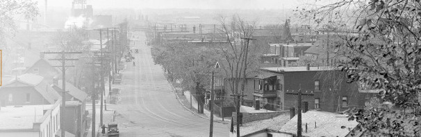
Here’s the current view, looking south towards Scott, from Brooke Claxton tower. The centre boulevard space remains. Disappointingly, there were no sketches of anything to enliven that strip that Greber insisted on so we can all admire the International Style architecture of the Claxton Building. In my mind, that strip desperately needs Landscaping and People.

Most employees in the new mixed Government and private sector office buildings will arrive on the LRT. In addition to the current 10,000 employees, projected to grow to 25,000* by 2040, there will be about 3500 new apartments. Many of these people will commute by transit too.
*[note: while the civil service may not be growing today, it has always grown faster than population or the GNP, plus the Feds plan to relocate a number of smaller workplaces into new buildings at Tunney’s. So yes, there will be demand for the government space]
The entry plaza near the LRT station would not be constructed until after the Western LRT is completed, maybe 2025?? The plaza is constructed upon the “temporary” bus terminal whereat those folks from Kanata and Barrhaven and other points west will disembark their buses and get on the LRT for the ride downtown and points east.
The new, very tall office tower shown on the right is one reason there is so much more residential space in the new plan compared to the one panned upon release last year, which kept civil servants in a lot of mid rise towers.

Below is the basic site plan. Note how many new residential buildings are proposed, well mixed and integrated throughout the site. This means there is a real opportunity to build a neighbourhood that is dynamic 24/7, totally unlike the current office buildings in a pasture that are dead at night and weekends.

In many ways the new plan reminds one of the original Greber plan for centretown, dating back to the 40s and 50s. Like the area along Metcalfe and Lisgar, there will be a fine mix of office buildings, retail, and residential uses, all in shared podiums that take up most of each block.
The new plan is designed to integrate with adjacent neighbourhoods, and be permeable to people travelling through. Alas, I do not have a picture of how the site interacts with the NCC Parkway (more on this in a bit). There is also a curious hard edge to the west, abutting Champlain Park. Surely a way could be found to permit residents there to access the new site, and the new ribbon of parks that runs through the site and Mechanicsville over to Bayview.

Below is an aerial perspective taken from the North, with Scott running diagonally from the middle left to top centre. Brooke Claxton building is at the bottom right, at the end of the existing Tunney’s boulevard. Note the row of high rises along Parkdale, and that the proposed new residential on the west side of Parkdale are low and mid rise. I suspect those heights will increase. Also note the abundance of low rises backing onto Champlain Park , to the upper right.

Now, flying around to the view from the South, the aerial picture below shows Tunney’s Boulevard starting at the LRT Station along Scott and ending at the current Brooke Claxton Builidng.

It is also quite apparent (picture, below) how many of the blocks are made up of a block-sized podium with office towers, or residential towers, or a mixture of both. The podium will have an occupied frontage along the streets, but the backs will be an above ground parkade, with a green roof. This green space will not be visible from the streets, only from the backs of the buildings. For a similar buildout, see Holland Cross directly across Scott from this site, although on that site the public can find a way onto the green roof of the parkade.
I am somewhat sceptical that there will be a perfectly paired market demand for both office buildings and condos at the same moment, which is required for these tightly integrated buildings which will share the parkade.
And I think the shared parkade is a great idea. It will require cutting the cord between the condo owner and an owned parking space, in favour of shared parking spaces. More efficient, yes, but new to our market.

Here’s a mid-block slice, that might show better how the parkade, with green roof courtyard shared by the office and residential towers, might unfold:

Part way down Banting Drive, the plan proposes a city park, to be developed when the surrounding buildings are constructed (ie, in the future ….). It is envisioned as a playing field surrounded by a border of trees, so office workers or residents can play pick up soccer, Frisbee, or whatever. The sketch below shows a very nice cafe (beer garden, maybe?) overlooking the park.

The City will eventually take over the Federal streets as the area is built out. It is apparent from the aerial views how strongly the traditional urban grid street pattern is being reinforced.
Banting street will be extended out to meet the Parkway at a signalized intersection. This will make three intersections on the Parkway in three blocks — Banting, the Kitchissippi intersection, and Parkdale. Apparently the NCC is kosher with the transformation of the Parkway from a scenic route with infrequent intersections to a more urban street with stop-go traffic.
The Tunneys Plan, like the parallel Scott Street CDP, depends on the NCC riverfront lands for active amenity space. The plans show city parks spilling over onto NCC land, more active uses of the greenspace, more like along Queen Elizabeth Driveway than the golf course-inspired frustrated hayfields that currently characterize the Ottawa River lands.
Some of the same planners were involved in both the Tunney’s and the Scott CDP plans, so they are well integrated. Surprisingly well. We should be encouraged … I only wish we had such careful planning and integration going on in the various Bayview-Carling CDP’s.
In summary, the finely mixed, well-integrated master plan seems to hit most of the right notes. I am sceptical that the low rises will remain as low as shown. After all, the Feds want to sell the development sites for top dollar, and the proposed heights matter. And developers, once building six or nine stories, will want to carry on upwards.
A lot of the future success or failure will depend on the details. How will loading docks work? Can the feds have secure buildings that also offer a nice street frontage? Will the traffic circles work? Will people really arrive by transit, or will the pressure from exurban and suburban worker bees be so strong that more parking appears? Will apartments attract families that contribue to the 24/7 vitality, or will the cost of concrete apartments translate into a monopoly of small units best suited for the college grad starting out their career of civil servitude?
You also listen to me on CBC.ca Ottawa Morning: from a land of cubicles.

Why the above-ground parkades? Why not put them underground?
Cost.
Charles: the bedrock is shallow. They propose one layer of underground parking and then show one layer of above ground parkade, but verbally acknowledge there might be multiple layers of above ground parkade, but since the buildings wrap around the parkade no one will notice, eh?
As I am doing, both Jan Gehl and Peter Calthorpe would probably point out that this TOD lacks a ‘core commercial’ area… somewhat important to creating a central node of activity to encourage inter-hub travel. The Tunney’s Pasture layout has potential to be a textbook TOD which is very rare to come by (correct size, single land owner, major arterial road bisecting the core for visibility to the core retail area by motorists, existing lower-density residential outside the 400m radius and on the south side of the arterial, etc.). The plan needs many bike connections to the Parkway and to the neighbourhoods east and west to capture the greatest number of transit users. The Scott Street cycle track with help greatly with this, but there needs to be more spokes in different directions. Visibility lines within the site should make it clear which way the LRT station is from anywhere within the site and the station should be a focal point. The development should allow for public access through the ground floors of many of the buildings so that mid-block pedestrian connections are available to provide shelter from the weather when walking to/from the station..