
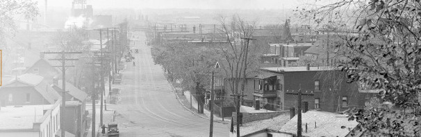
The current Dominion Station is currently a bunch of bus shelters where the transitway trench made a temporary curve to connect buses to the Ottawa River Commuter Expressway, aka Sir John A Macdonald Parkway:

When converted to rail, the trench will be more aligned with the current cycle pathway and will wrap around towards the bottom of the photo parallel to Dominion Avenue.
The new station will be relocated a short distance eastward to be parallel to Workman Avenue and the north end of Dominion Avenue:

The new station will provide excellent transit-access to the (being reconfigured) riverfront parklands. This is of huge importance to the future.
It appears the current ped-bike bridge at Roosevelt Avenue (top right corner of the aerial photo) is gone, replaced by the wide crossing at the new station. Roosevelt provides a good N-S cycle route and has a signalized crossing at Richmond Road and Carling Avenue while providing convenient access to the Highland Park area. I hope something is done to promote continued easy cycling connectivity east, west, and south. (ie, more than a sign tacked up high on a post).
This station continues the new, simplified architecture, with a flat roof.
As befits design where the NCC has a say, and the neighbouring houses valued in the millions, the landscaping is lush.

______________________________________________________________________________________________________________
Further west will be the first of the brand-new-location stations on Phase 2, Cleary Station.
Here’s an aerial view of Richmond Road near Cleary now, seen from a pigeon flying above McKeller Park, with the Continential condo on the right, the Unitarian church at the top right, and Kristy’s in the centre, facing the old Byron tramway and its park treatment:
![]()
And here is a similar view showing the new Cleary Station:
![]()
The LRT line is buried quite shallowly, constructed by “cut and cover”. To save building an indoor station, the platforms are in an exposed cut similar to the current transitway trench along Scott, except much narrower. I recall that there will be slightly fewer streets crossing the park, making for a more continuous linear park and traffic calming Byron. With defined road edges on Richmond and Byron, I expect the greenery of the park to be wider, ie there may well be a net gain of parkspace.
Like other Phase 2 and 3 stations, the building is more modest, with a flat roof.
![]()
Richmond Road is traffic calmed to two traffic lanes, new sidewalks and cycle lanes/tracks. There continues to be a dogwalking path winding along the length of the Richmond alignment.
Bus routes like the 87 that currently service Woodroffe Avenue and then go downtown via the Parkway will instead loop around the Station and passengers will transfer to the LRT. Routes like the 11 will continue to provide local service along Richmond Road. Eventually commuter bus routes from Nepan and Barrhaven will feed into major LRT transfer stations like Baseline and Lincoln Fields.
Further west, an identical station will be constructed at New Orchard Avenue. They will be bookends servicing the McKellar Park and Richmond Road neighbourhoods:

Of course, by time the New Orchard Station is built redevelopment of the low-density 1960s-70’s car dealerships will likely be under way. Expect lots of high rises providing boomer retirement homes and big-city living.
I hope the city manages the planning to make the north side of Richmond Road an attractive, walkable street with varied storefronts, and not a bunch of widely spaced high rises separated by windswept “open spaces” and parking lots.

This platform-level photo illustration applies to both the Cleary and New Orchard designs:
![]()
__________________________________________________________________________________________________________
Next: moving further west …
I agree when you say “I hope the city manages the planning to make the north side of Richmond Road an attractive, walkable street with varied storefronts, and not a bunch of widely spaced high rises separated by windswept “open spaces” and parking lots.” I think of the Ashcroft condo area down the road as needing more work in that respect. We just moved to the area from Wellington West and it’s quite a shock giving up the interesting ambiance from Golden to Somerset along Richmond Rd and Wellington. No traffic jams though, like there are in our old ‘hood. Biking should be good and walking too if they ever build safer sidewalks in mind for the connecting North Streets that could benefit (on Sherbourne for example).
So I can hazard a few guesses but what was the rational for building the more expensive stations for Phase 1?
Architectural vanity, mostly.
Glen – Ph 1 had more complex stations in terms of many grade levels, and being major transfer points eg Pimisi, bayview, Tunneys, Hurdman. They will handle large volumes of passengers. Stations like Westboro and Cleary are not major transfer points, are shallow to the surface, and are simple entrances and exits to the line for the neighbourhood and local bus. Stations at Lincoln Fields, Algonquin, etc will be large to handle the volumes, transfers, and grades.
One benefit of the removal of the busway connection at Dominion Station is that the SJAM winter trail will be able to continue westwards on the south side of the Parkway, possibly as far as Woodroffe Avenue.
I hope with the new location of the Cleary station, they get around to renaming it to the Sherbourne station. The station is no longer at Cleary, and Sherbourne is a more major road anyway.