
: Mixed Use")
The Gladstone CDP covers an area that was once an industrial heart of the City. There are many “brownfield” areas (former industrial sites, possibly contaminated) and a number of ongoing industrial uses:

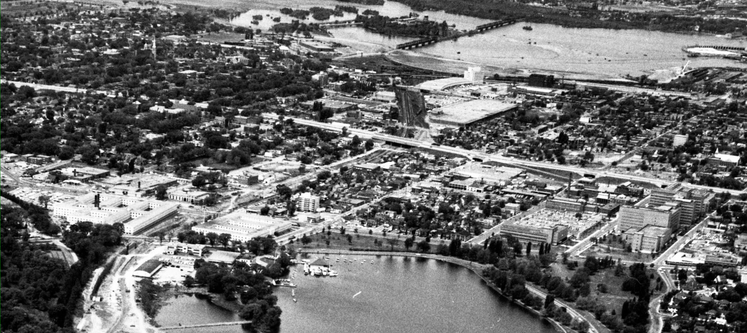
In the Google Earth view shown above, the big reddish building is the PWGSC warehouse at 1010 Somerset, also known as the “Oak Street complex”, and most recognizable to passersby for the outdoor stoneyard along the OTrain bike path. On the west side of the tracks, the Canada Bank Note building and its huge parking lot take up an entire block. The triangles of land between it and the OTrain cut is home to a variety of small industrial users (Beacon Light, glass factory, former bread factory, storage yards, garages, etc. The triangle formed by Gladstone/ Loretta/OTrain is owned by Regional Realty. Down at the bottom of the aerial photo is a large building holding the City’s signals branch and a former factory.
The block south of Gladstone the City concept plan proposes in all three Options to preserve the City signals building and (someday) replace the factory along Gladstone with two mid rise buildings on a shared podium:

Number 9 is the proposed OTrain piazza above the tracks. Loretta is the unnamed street running north south, between Breezehill and the OTrain. The white building is the City’s signals yard surrounded by a gray zone. While the facility won’t be relocating in the next decade, it is somewhat an oversight to see that planners ignore its future development potential. All along the Gladstone block the options propose mid rise mixed use development (residential above retail, commercial, or office uses). If the City included their own parcel in the plan, they could propose higher development along the OTrain cut stepping down to four stories along the Loretta side, which faces an existing low-rise neighbourhood.
There is a tendency in Ottawa to view non-residential non-retail uses as necessarily being office uses. That is because Ottawa has a very high white collar office sector and minimal industrial sector. So in the City planners’ minds, mixed use means offices. Office uses are relatively compatible with residential uses, being fairly quiet and generating lots of car traffic during the day and modest truck traffic in the evenings and nights. Now consider the north side of Gladstone, along the OTrain corridor:

The development sites on the west side of the tracks (left of Numbers 3 and 6 in the drawing) are proposed for primarily residential or residential-office. The big gray blob with the white building is pure industrial — manufacturing. Canada Bank Note is spending big dollars to renovate the plant. It has tractor trailer loading docks on the east side, facing the new apartments.
Conflict, or at least interesting sights to see from your apartment window …
This indicates some of the difficulty in transitioning a neighbourhood from industrial to residential. Not everyone has enough money to buy up all the land and clear it first (see Lebreton, still-Flat, NCC). Remaining factories can be noisy, particularly if they operate 24/7.
I have lots of sympathy for the industrial land users *. They were here first. On the other hand, the City is spending billions on transit, and plans to recoup the cost through development charges from high density intensification around each and every station. In the City’s OP, there is no room for industrial users or low density storage yards on mainstreets or transit corridors.
______________________________________________________________________

North of the site above, along Breezehill (on the left in the illustration above) running up to Somerset, the City proposes some version of intensification in medium rise (5 – 9 storey) or high rise (10-20 stories). This is the block most of us will picture as being across the street from Devonshire School. The corner site (marked number 1 on the drawing) is already owned by Claridge and zoned for about 30 floors. Regardless of the zoning suggested for the area, individual developers are entitled to ask for more. If the City doesn’t grant it …. the OMB might.
The big blue area on the map above is the PWGSC site, presently occupied by storage and temporary office space. All city plan options show this as four office towers on top of two connected podiums. The drawing above has a (yellow tinted) piazza between the office uses and the new Oak Street connector across the OTrain (Number 2, on the map). I suspect this won’t stay there long, but will be rolled into the office site.
The new north-south street running on the east side of the PWGSC site (it does not interfere with the businesses along Somerset, the map colouring is imprecise here) provides access to the office site. Another access point is where City Centre Avenue sorta-dead-ends at Somerset and then extends as a semi-private lane under Somerset onto the PWGSC site. This is likely to become a key parking garage entrance to the office site.
Note that while the plan shows the land use as offices, making for a complete live-work-play neighbourhood, the land owner could eventually decide to construct condos instead. Office uses are notorious amongst adjacent residential neighbourhoods for their spill over parking contagion. The areas around Booth Street NRC offices are stuffed with parked cars, and many residential landowners yield to temptation, paving front yards and back yards to park cars at $100-200/ month each. These proposed offices will flood the adjacent areas with daytime parkers (the proximity to transit at Tunney’s hasn’t stopped it there, so proximity to the OTrain won’t prevent it here either).
Here’s how the City imagines the area from Devonshire School to the Plant Pool to look like (but recall, their drawings usually choose the lowest height elevation from each range. If it’s zoned 10-20, they show 10 to 15. We know it will be 20. Or more):

Another post will deal directly with the road network options, but the proposed road between the offices and the park seems odd. The same planners abut offices directly onto a park in the Tunney’s Pasture CDP.
Indeed, one of the strange aspects of dealing with City planning studies, even when conducted by the same people and consultants, is how disconnected each one is from the adjacent one. It’s as if silos of separation MUST exist !
_____________________________
*disclosure: prior to retirement I was an industrialist in this neighbourhood (City Centre)