
")

Will the redeveloped Tremblay Station area be better than what is there today? Will there be a wonderful world of tomorrow, or just a bigger – higher – denser version of autotopia?
Here’s a city-provided sketchup of the Tremblay LRT Station (formerly known as Train). Construction starts in December this year, for completion in July 2017. The ring road that services the train station is visible at the top; with the VIA Station at the top right. The parking lot shown is existing, but not for long.
While the main LRT entrance is to the east, by the ring road, there is a secondary entrance shown at western end of that very long train. It is shown going to the parking lot, but when that lot becomes a 30-storey office building, it might be a direct entrance to the building, or maybe even the start of a way to get south, beyond the Via Station, over to Train Yards.
The very nice glass roofed area along the ring road – shown below – doesn’t extend all the way to the VIA Station. The parking lot entrance is too important to interrupt.

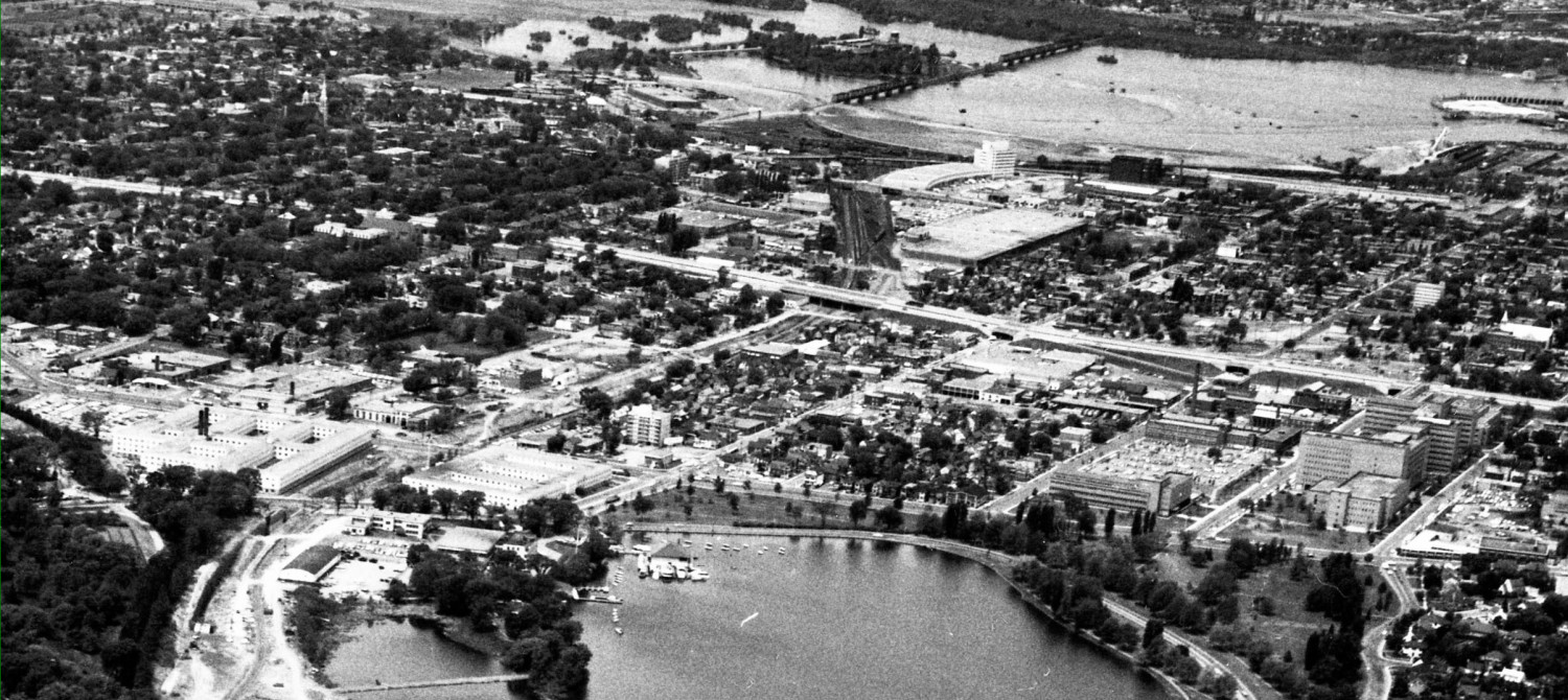
Shown below is a Google aerial photo of the area, with the ring road to the VIA Station very visible, the thin line of the Coventry Bridge, and the baseball stadium. Presumably one is to walk out to Coventry Road using the lane in front of the Stadium. Once there, Coventry itself is a pretty typical 1970’s looking and feeling suburban “arterial” (aka traffic sewer, choose your vocabulary).
The City is constructing bike lanes on Coventry, and maybe even some segments of bike tracks (bike lanes set back from the traffic, adjacent the sidewalk, like or Churchill). Better than what is there now. Note too that in the planning horizon, St Laurent Shopping Centre will expand into the area just right of the orange dot (shown below) and Coventry will be rearranged northwards to go around the New Wonderfully Expanded Parking Lots:

The City has a intensification plan for the area shown above. In big block terms, it is thus:

Those red blocks are 30 storey buildings, one on each parking lot beside the VIA Station, and a bunch behind the Station tracks along Terminal Avenue. The yellow star marks the new Tremblay LRT Station. I expect the area to be a mix of apartment towers a la Hurdman style, and some office towers should / when the Feds need more space. I do not expect it to be a pleasant urban environment, rather it will be, in the suburban vocabulary, “park like” with separate buildings close together in splendid isolation. Like Hurdman.
Here’s the planner’s porn view, although most of the towers seem underbuilt according to the plan. In some areas, the City considers the zoning height to be the minimum acceptable development, but I don’t know if that is the case here:

A pedestrian connection will be essential to get from the new LRT Station to those new residences and offices, and that is shown on the ped plan by a faint blue conceptual line behind the VIA Station:

Otherwise, the ped plan just shows sidewalks glued to the edge of the roads. Where people want to drive, people who walk must want to go to too. What’s good for cars is good for walkers.
It certainly isn’t Transit-Oriented-Development, or ToD. It is typical last-century road- oriented development parcels that happens to be near a transit stop. There is nothing organizing or focussing the area around the transit station, or making walking a priority, or encouraging development from the pedestrian / transit spine outwards. Where is that broad pedestrian avenue, lined with Tim Horton’s, with day care and a senior’s residence and parkettes and ponds and trees and cafe’s??
(Go back and look how Portland does real ToD better, read three stories here: https://www.westsideaction.ca/building-lebetter-flats-part-7-view-portland/
In Ottawa, walking is squeezed in as an after thought to motoring. Why isn’t there a big bold blue STRAIGHT-ish line showing a pedestrian spine running from Coventry, in front of the Stadium, over the bridge, crossing the LRT Station, and through / beside the VIA Station over to Industrial Avenue? The very crookedness of the City’s current path, its interrupted nature, it’s deviousness, reveals all. Potemkin village ToD. Faux Urbanism. Traditional suburban sprawl writ big.
There is a plan for people who bike, too. It also starts with the motor vehicle plan, and grafts onto it some sharrows and minor facilities. Better than what’s there now, which is nothing.

Despite the million dollar Coventry Bridge, there is no bold cycling spine through the planning area, nothing to lead one to want to cycle to the Stations. There will be a devious wiggly route for the truly deluded people who will cycle here. This plan is a sad under-reach that results in under-achievement (pardon my mincing words here).
Look at that sketchup once again, and see if you can spot the transit-oriented plan? If you block out the LRT Station with your finger, would the plan look any different?
On a more cheerful note, maybe it will be years before the area redevelops, and the plan might be updated. There’s got to be a pony in here somewhere.
Next: Queensview ped bridge: deja vu all over again?
I totally agree, Eric, it is certainly not a pedestrian, cycling, or transit oriented plan. If anyone needs to be convinced of the mind-set of the planners, simply look in the porn picture at the sidewalks around the VIA ring-road; the inside sidewalks STILL will simply end part way around. If it was good enough in 1966, then it’s good enough for the next 50 years; don’t change a thing.
“In Ottawa, walking is squeezed in as an after thought to motoring”
Just look at the pitiful dangerous partial narrow pseudo-sidewalk on the new Vanier-Riverside bridge over the 417 highway.
The thing that bother me about this being TOD is that most of the area inside the “accessibility circle” around the station is taken up by the 417/Riverside/Vanier interchange. That says it all.