

Just where to put all those transitway buses when the transitway closes in 2015 remains elusive. You probably read the Citizen story http://www.ottawacitizen.com/news/ottawa/Scott+Street+replace+Transitway+during+project+city+saying/9157057/story.html. This will provide some more info, and an alternative “solution” to Jeff Leiper’s.
The transitway section of concern is between Tunneys Pasture and Empress (where the Good Companions Centre is, and the transitway joins the beginning of the Albert-Slater one way pair that goes into the downtown). The City has to take the buses off it, in order to build the Stations at Tunneys and LeBreton; and to convert the asphalt bus way to tracks for the trains.
While community associations and councillors made a lot of noise about diverting the buses to the Queensway, Carling, the Parkway, or indeed anywhere but Scott-Albert, it was always obvious to me that the simplest “solution” was to put them on Scott, as it parallels the transitway, riders won’t get lost, and schedules will remain pretty much the same.
This has rather dire consequences for the adjacent householders, though. Along Scott, there are homes and businesses that have lost their setback from the street due to previous road widenings. There are driveways, too; and a number of side street intersections.
On the Albert section, the homes of Walnut Court, 35 Preston, and the first phase of LeBreton flats (constructed in the early 1980’s) back onto the street, with varying levels of walls and fences. East of Booth, to Empress, the situation reverts to traditional red brick homes facing the busy street.
Community reps (including myself) last met with the Rail Implementation Office folks on October 2nd. They still don’t have any plans of how to handle the buses. In a complex, dynamic environment like the LRT project, I’m not surprised that they are focussing on what needs to be physically done first rather than what needs to be done later on, when the “later on” is for the peace of mind (or not) of residents rather than an essential cog in the construction process. It’s also much easier to “force” the solution on Council at the last minute if there isn’t time to explore alternatives.
The Albert section is complicated by the still-undesigned Albert-Booth intersection, which has been ballooning in size and complexity as the traffic boffins try to fit in traffic, buses, bike lanes, sidewalks, and ped waiting areas. To say nothing of the long concrete bridge that takes Booth high over the LRT tracks; it has grown enormously and unacceptably wide, and expensive.
Where is the Boxfish Group when we really need a total rethink here? Could we please get a bunch of consultants and locals into a workshop to hash out something totally new?
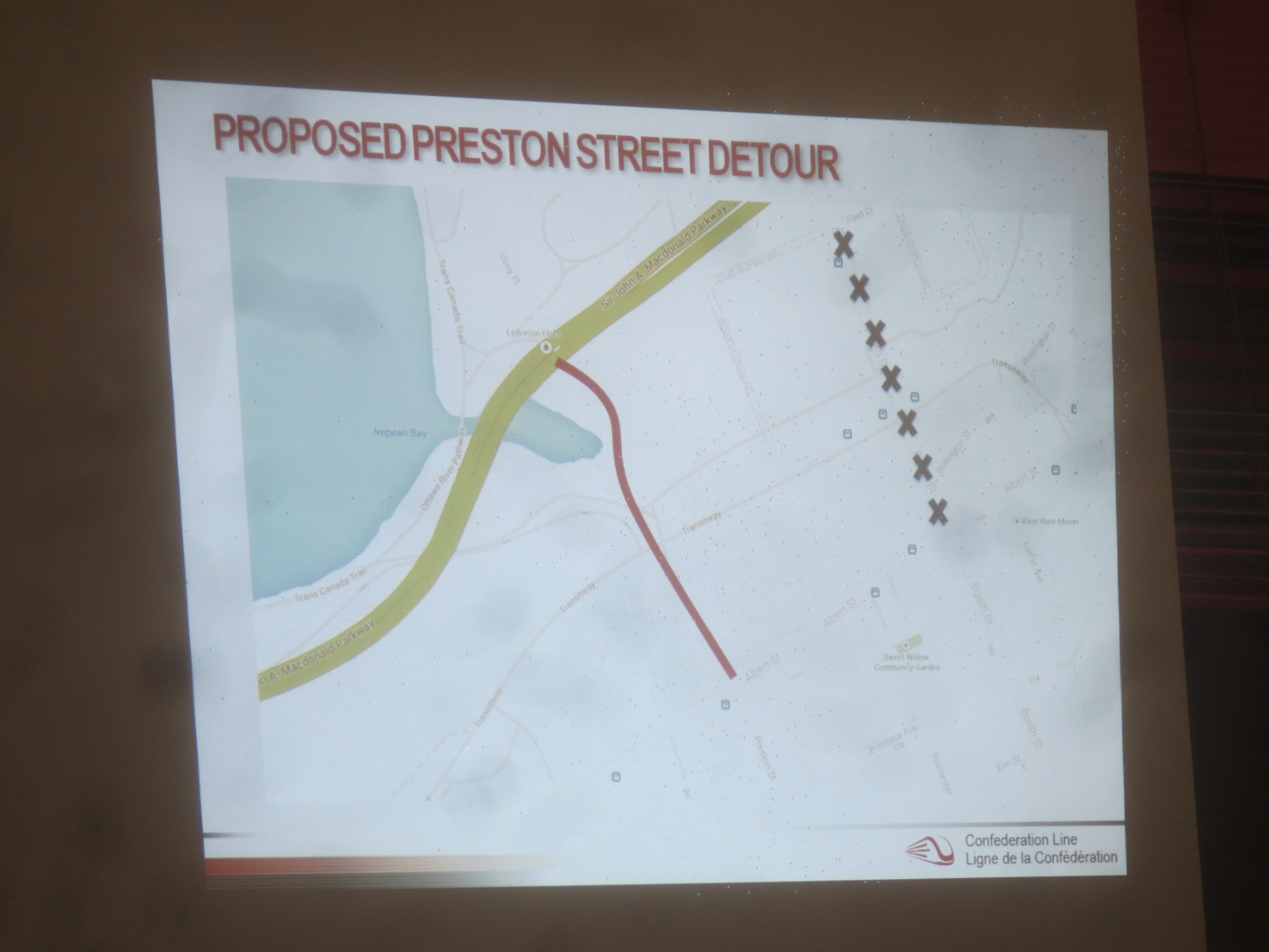
And don’t forget, Booth has to close (xxx’d line, below) for several years during the LeBreton Station construction period. Traffic will be detoured on a temporary road (red line) built north from Preston over to Vimy Street intersection in front of the War Museum. All this complicates the road geometry enormously.

Do I have a suggested solution? Of course.
While the buses are put onto Scott-Albert, we want to minimize the regular commuter car traffic on the road. Individual motorists can find their own alternative routes. So, I’d put the two bus lanes in the middle of Scott-Albert, with an east bound local car lane on the south curbside, and and westbound local car lane on the north curbside. This avoids any “contra flow” situations.
Once the buses leave Tunney’s, and get onto the centre lanes, they won’t be needing curbside bus stops, remember, these are express or 95 type transitway routes. So from Tunney’s east ward there would be no stops until the OTrain station at Bayview. I’d go for a road widening on each side of the overpass** over the train tracks, with island platforms for bus passengers. Eastbound on the east side of the overpass; westbound on the west side. [Or vice versa, if you want buses starting on the downslopes].
The island platforms for passengers would be separated from the outside car lanes by jersey barriers with a 3′ glass splash shield on top. Rather like the Spadina Streetcar stations in Toronto. Passengers would have only a single lane of traffic to cross to the to the outside sidewalk and walkway down under the bridge to the existing OTrain platform.
If OC Transpo wants to permit transfers at the new Preston extension over to Gatineau, then a similar station would be required at Preston. However, this is pretty close to the OTrain station … and I question if a stop is needed at all (more on this below).
IF a station is built at Preston, putting centre platforms running down Albert, they would not bugger up the existing Preston-Albert intersection, because there will no longer be all the Albert traffic turning onto Preston, or turning onto Booth to go to Hull, or coming the opposite way. Instead it would go straight north-south through the intersection, sans turns, making the jog over to Booth and the Chaudiere Bridge via the New Wellington in front of the War Museum.
The reason I think we could “do away” with the temporary station at Preston to replace the out-of-commission LeBreton Station at Booth, is because there are alternative transfer opportunities uptown or at Tunney’s.
And because post-LRT opening in 2017-18, the city intends to run a limited number of 95-type buses east from Tunney’s and directly over to Gatineau on Booth, so that west end riders won’t have to transfer at Tunneys (onto the LRT) and again at Bayview (to the OTrain) or LeBreton (onto a bus to Gatineau) *. Instead of waiting until 2018 for this new bus scheme, implement it now, to avoid a temporary LeBreton Station.
Similarly, bus users from the east would transfer to Hull buses in the downtown, not at LeBreton, during construction.
So for the bus rider, coming from the west, the bus would follow the transitway to Tunney’s; then the temporary transitway down the centre of Scott, to a temporary station platforms at Bayview, continuing along Albert to possibly a transfer station at Preston (but maybe not …) and thence further east to the resumption of the existing transitway lanes on Albert and Slater starting at the Good Companions.
So what happened to the car traffic now on Scott-Albert?
The presence of the bus lanes in the centre of the street would mean a no left turn restriction for the whole length of Scott-Albert between Tunney’s and Good Companions. The restriction is necessary for the safe movement of the buses (see, for example, difficulties if this isn’t done, as in Dallas or the new Rapibus system in Gatineau). This restriction will scare away much of the rush hour through traffic.
We’ve closed Bronson for a year, and traffic found alternate routes. We’ve closed two lanes of Scott-Albert for two years of pipeline construction, and traffic found alternative routes. So closing Scott-Albert again doesn’t bother me.
Locals would still use Scott-Albert to access driveways and side streets (right turns only). Instead of left turns, motorists would have to rejig their routes so that they cross Scott-Albert only at right angles, at signalized intersections (Holland, Parkdale, Carruthers, Bayview, Preston).
Removing the majority of commuter traffic from Scott would reduce traffic noise and proximity, minimally compensating for the additional noise of 190 buses per hour per direction on the centre lanes. The Hellish walking conditions on Scott-Albert would also need attention, although these haven’t bothered the city to date.
The above scenarios might work, and I toss them out for discussion.
The alternative isn’t to propose something magical that won’t happen (put them on the Parkway !), or to wring our hands at the additional noise, or to wait until the city delivers a fait accompli at the last minute. Provided the street is repaved before all the buses hit it, residents should be able to withstand two years of bus traffic.
The city’s compensatory offer, of course, dangling on the horizon, are the “complete streets” drawings they are now flashing about the community, with double tree’d boulevards (tree, sidewalk, bike track, tree), three to four lanes of traffic, and tree, bike track, sidewalk, tree, again.

Do we accept the city’s promise to implement these complete streets when there is no guarantee they will be promptly implemented?
And alas, this complete street misses the number 1 cyclist choice for an off-road bike path, but the bike tracks will work, even if 4th best, because they are better than what we have now. http://ottawabicyclelanesproject.createsend1.com/t/i-l-atrtdy-ikkkhluh-z/
_____________
* the city currently starts the westbound run of a few 95 type buses from Place du Portage in Hull now; I am just adding a few more, and a reverse route in the mornings …
** but not widening the overpass itself; the temporary station platforms would be on the slopes to and from the bridge portion.
Wouldn’t your solution of putting the Transitway into centre lanes on Scott create a complication somewhere around Empress or Bronson when the buses have to shift to/from the downtown curb bus lanes? And, similarly, the cars have to cross into or from the centre lanes? That is, there’ll be a slew of weaving manoeuvres around Empress.
Don’t get me wrong: in another context it might work quite well. For instance, if the downtown bus lanes were actually on the left curb with island platforms in the left middle lane, then your solution would work really well.
David: I couldn’t address every feature, because the story was already pretty long and mind twistingly complicated. But the cross-back to regular side movement is actually very easy to handle. Albert-Transitway is already a signalized intersection in front of the Good Companions Centre. Sometimes, the centre lanes temporary transitway would get a green light; and sometimes it would be the outer lanes. As they go through the intersection or just beyond (I put this last caveat in for those who claim it is illegal to change lanes in an intersection) they end up in their correct lane. Since there is already a signalized intersection here, there should be no additional delays, or surprises for motorists. Key to doing this is to make sure each lane of traffic sees only their correct lights, something I am confident our signalling boffins could figure out (hint, use arrows on the signal lamps…).
thanks for commenting,
Eric, why not simply convert the north lanes of Scott-Albert to the surface busway, instead of the middle lanes? There’s no development on the north side, so it seems like a much simpler solution.
Erinn: the problem with the north side bus lanes comes at intersections. Picture yourself going north on a cross street, you stop at the red light, waiting for a green to turn left. What you see in front of you is lane 1, eastbound, 2 cars and local bus. Lane 2, empty (its actually the westbound lane for cars and local buses, but remember, their light is going red…), Lane 3 is eastbound, with three buses queued up at the light; Lane 4 is actually the westbound bus only lane. Its 5pm on a weekday night; the kids are squabbling in the back seat; spousey is telling you of some boring workplace event. Quick: what lane do you turn into? All our driver training sends you to Lane 4, on the far side of the eastbound traffic. It is highly unnatural to turn into lane 2, between two lanes with buses heading east. All contraflow and parallel flow roads situations have this driver recognition problem.
I haven’t addressed every issue with north side vs centre lane; I am tossing the idea out for discussion so we have thought about things before the city comes to us with their solution.
This may not be the best option but it is the most well rounded and logically grounded option that has been put forward. I would only add that the bus lanes be separated from the outside lanes with the temporary barriers like the ones separating the bike lanes on Laurier from regular traffic. They would be cheap to install and completely prevent the Rapibus difficulties.
When the city/NCC built the parkway/wellington (highway) a couple of blocks north Albert st should have been reverted to the nice main street it should be. I’m worried that they’ll just widen it endlessly as part of the LRT construction and then leave the 8+ lanes of road there when they’re done leaving the area with a blight that has to be maintained.
Eric: that is exactly our community fear too. Once the LRT opens, some whiny Councillor will say “now its time to do something for the motorist” and the extra-wide road will stay in place; or the mayor will say “we’ve got no more money” to put the road back into proper order. As you may now, there is no way to hold the city to its half of any trade off, or to any committment, since no council can bind the next one, and council regularly “changes” or breaks promises.
To be clear the complete street at this point is a proposal generated during a community design plan . It’s a very good idea but will need lots of support for it to become a ‘ city promise ‘ the start of that would be to help Councillor Hobbs to make planning committee understand how important it is to your community and then council. I will be.
George: thanks for the response: The complete street model seems to be sweeping city hall these days. The City brought to us a virtually identical scheme for Albert post-LRT, although they quibbled over the funding for the bike track. And they cheerily told us Scott would likely get the same, as its in the Scott CDP. And a different bunch of Toronto consultants are promoting the same cross section, but with more lanes, for Carling Avenue. While the City may not have accepted or approved these cross sections pending study completion, I suspect they are not there without the blessing of the technical advisory committees as the city isn’t likely to let consultants make major proposals that they are opposed to. I suspect all these complete street drawings are showing up because that is what the city wants.
This is a really out there solution that I have absolutely no expectation will happen but why not pretend like the lrt is already in operation and just have one “transitway” bus go down Scott and Albert at 5 minute or less frequency? East and west commuters could transfer at Hurdman and Tunneys or Westboro or Lincoln Fields (sorry I’m not very familiar with the far west side of town). Those buses would always be on time too because they’d be at the start of the route. Sure commuters might not have a bus that goes from their door to their office but the buses they take would be on time. It would also be much less complicated for travelers in the city center to figure out.
Betsy: I agree with you 100%. It is hard to find out what is “wrong” with your idea, but previously the city has indicated that they think users will be willing to transfer from bus to LRT at Tunney’s because the LRT will novel and wonderful, and take you into those (now downsized) underground stations; whereas transferring buses will be dreadful and discourage traffic since people will still be using the bus stop at Minto Place et al.
Note that 5 minute bus frequency wont replace the 3-5 minute train frequency; it would have to be one bus every 45 seconds or so, to have the same capacity as the LRT.
Your solution also gets rid of a bunch of direct express buses (rush hour, not the 95’s) that clog up the transitway.
OC Transpo is properly concerned not to make too many changes, or to discourage traffic, as it is hard to win it back.
thanks for commenting,
As a resident of Scott that has the most to lose in all of these situations, I would suggest that all bus lanes be kept to the north side of the street. A temporary solid divider would separate bus from regular traffic. There are still many accessibility issues for residents of mechanicsville that would need to be dealt with (pedastrian safety/accessibility to retail and services, child walkability to schools south of Scott, cycling safty etc.) but this gets the buses as far from homes as possible.
That said, none of these scenarios address the extreme noise or the inhospitable air quality issues that arise. Buses on Scott will not be able to travel at speeds even close to those on the transit way and they will be stopping, accelerating and idling for extended periods of time in front of our houses. If any one is unaware of the detrimental health effects of deisel particulate matter, especially when it comes to child development, than a quick search would find more than enough scary data for us to be concerned as parents!
Pretty easy to toss out suggestions when it’s not your families health and reasonable enjoyment of property! Homes will be unsaleable for the near future, tennants are already giving notice that they will leave before the detour happens as they do not want their children to endure this. Noise and exhaust will make the homes unliveable!
It’s reasonable to expect that sacrifices be made for the future growth of the city but the sacrifices of some will be far greater than others! Put yourselves in our shoes before dismissing our concerns. Be glad it’s not your lives/homes being affected.
As usual, a constructive contribution, Eric!
I sympathize heavily with Chris, and am far less inclined to give up on finding alternatives to dumping all the buses onto Scott for two years. If you want a feel for how close those buses will be, stand at the fence on the north side of Scott where it comes out of the trench at Merton. You’ll be a measured distance from the buses to the front doors (and windows) of the houses on Scott. There will be 192 of those an hour during peak moving one way (presumably fewer going against the flow) according to the Rideau Transit Group. It’s not acceptable.
The NCC has indicated its amenable to at least considering a proposal for a temporary re-routing buses onto the SJAM, and we have to explore that rather than throw up our hands and go down the path of least resistance as a default. There are some eminently sensible reasons to consider a detour, not least to consider alternatives to the two traffic lights and multiple crossings that the traffic folks will have to deal with if they use Scott. There is also the potential to plunk the civil servants at Tunney’s much closer to their door.
Eric has, of course, put his finger on the key concern: once buses begin traveling on Scott, they may well never be taken off. There is simply no plan at this point for post-LRT. At the very least, if the City is going to forge ahead with re-locating the BRT to Scott Street, there should be some real assurances that it is actually temporary. We’re making assumptions, but to date there have been no real commitments.
How should Scott be re-configured if the Transitway does get re-located to run along it? Residents want the buses as far away from their homes as possible, thus the proposal to bunch those lanes as close to the trench as possible. We need to think through a number of options, obviously. Eric’s proposal may well be more sensible, and I’m glad he’s contributed it. But, at the end of the day, I don’t agree with the underlying thesis that the buses absolutely have to go on Scott. I’m looking forward to some pencil-sharpening.
I wonder if the NCC can be appealed to, to let the city use the transitway. The transitway buses could go past dominion straight through to…Booth? (I’m not sure where it would be needed to rejoin the system). A temporary line of buses could then run from Dominion to Tunney’s/Booth, back and forth along Scott. So commuters could transfer to these buses if need be, but the traffic on Scott would be much lighter.
Ah, nuts, by transitway I of course mean the parkway. Sorry about that.