

A number of speakers at the recent City Hall open house on the Western section of the new LRT line (WLRT) favoured the Carling route. That route has a number of advantages, including distance from many of speakers favouring it over the Richmond Road options, a belief that there is more intensification potential there, and a firm belief that the WLRT should take priority over any other future LRT routes, so if the Carling-OTrain route knocks out the attractiveness of future southward or northward LRT routes that would have otherwise used the OTrain cut, well, too bad for them.
A lot could be written on each of the above arguments. But today lets do a thought experiment. It takes a number of assumptions, and hostile readers can surely throw up a lot of objections. But if gentler readers will bear with me, follow along.
The Richmond Road options are currently costed at under a billion dollars. The Carling-Otrain option at more than two billion. That’s OK, some people say,Carling is still better because there is more intensification potential along Carling.
But, it is also true that the Carling option is way more expensive right out of the gate. So the first chunk of intensification is required just to pay the additional cost of the more expensive Carling option.
The cost can be calculated per rider for Richmond Road (the underground route, or green line option) and compared to the Carling option. The cost per rider for the Carling option is 2.45 times higher than the Richmond option.
So how many new riders do we have to get on the Carling section of the WLRT * to bring the cost back down to the Richmond option?
The answer is we need 313,000 new residents along Carling. These people are going to be much more likely to use transit than the average resident, so the assumed modal split is 40% (rather than the target 30% for the city as a whole, up from today’s 23%). This assumption gives us 125,000 new daily riders. And their farebox revenue brings the cost per rider of the Carling option down to the same cost as the Richmond green line option would have.
The spreadsheet showing how that can be figured out is shown below. It is NOT my spreadsheet, and it is NOT my intention to argue endlessly with commentators as to how the equation works. Please be satisfied that I found it, and am sharing it with you.
And because the fun part is beyond the table:

So, we need 125,000 new daily riders to get the Carling option to the same cost per rider as the green line under Richmond Road. And the 313,000 new residents along Carling coincidentally happens to be the population growth for the entire city out to 2031.
So we are going to have to ban any and all new residential construction in Kanata. And Barrhaven. And Ottawa South. And Orleans. Which probably means no more commercial construction in the ‘burbs either. Instead, every single new resident of the City between now and 2031 will have to live on Carling Avenue. And presumably we can retrain all those low-rise construction people how to build high rises, because we can’t fit all those new residents into low rise wood-frame construction just along the Carling corridor.
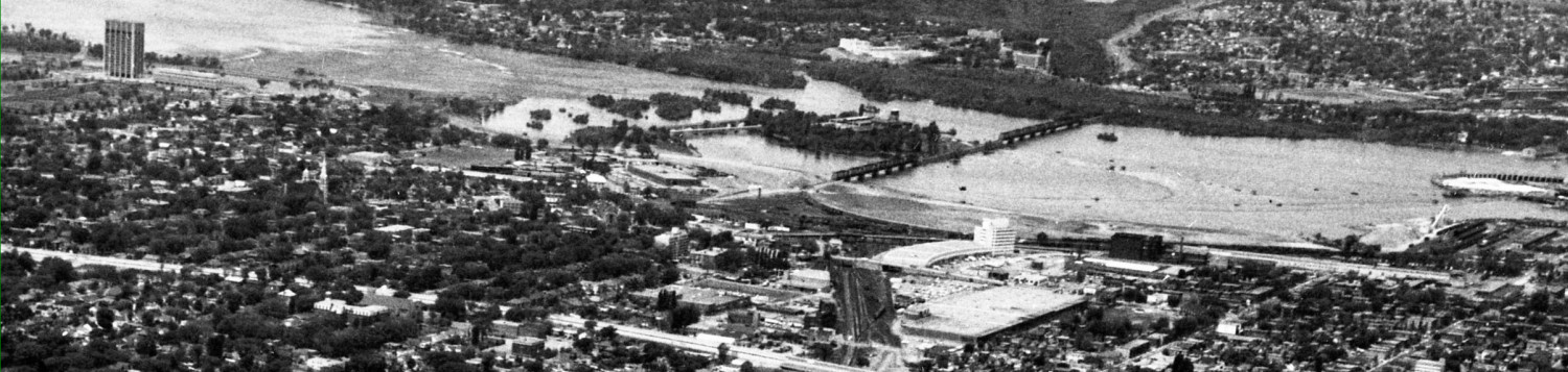
The Carling corridor from the OTrain track to Lincoln Fields is about 23 traffic-lights long. I’m using traffic lights because its a number I have handy, and makes for a fairly understandable way to break up Carling into a lot of little segments.
Let’s further assume that a 50 storey condo tower can hold about 250 apartments, or 500 people. To house those 300,000 new residents, we will need SIX HUNDRED new 50 storey apartment buildings.
Assuming they were evenly spaced between the intersections, that’s 26 new 50 storey buildings between every set of traffic lights along Carling Avenue. We might actually be able to get 26 into the Carlingwood Mall site. And maybe 13 into Westgate. And six into Hampton Park Plaza. And maybe a bunch south of the Canadian Tire, if we get rid of the industrial stuff that’s there now.
I’m afraid we might have to take out the two kilometers or so of Experimental Farm, running along the south side of Carling, to build more condos. Perhaps the Civic’s helicopter pad can be relocated to the roof of one of them.
And many of the lots along Carling are rather shallow, where the next street back is Woodroffe Park, or the south side of McKellar Park, or Carlington, or the Civic Hospital neighbourhood. Those residents will surely be thrilled by a “wall” of fifty storey buildings all along Carling.
And don’t forget, our increased modal split wasn’t just because the residences along Carling were nicely along a transit line. Carling simply cannot handle the 60% of residents that will drive to work (180,000 vehicles/day…). I guess they’ll have to drive north to Richmond Road or south to Baseline before heading east or west.
And for the 40% who take transit, their workplaces have to also be along the transit corridor. So a high proportion of all new jobs in Ottawa between now and 2031 will also have to be on the Carling corridor. This will be the equivalent of several Tunney’s Pastures (which is our third largest employment node in the city ….). Until 2031,maybe all those jobs will be building new condos along Carling, but after that… or for people who aren’t planning to be in construction … we are going to need a lot of tall office and commercial buildings. To quote our mayor, “a lot more tall buildings. Very tall buildings.”
And once we have built those 600 new 50 storey condo towers, killed suburban growth, and figured out how to force all new residents to live in said towers, we are exactly where? Well, right back at the 2013 starting point, since all this was required just to get the Carling route down to the same per rider cost as the Richmond green line. Now, we can start exploring those intensification opportunities that are so lauded as being easily found on the Carling corridor.
_________________
*all the new residences are put on the Carling segment of the LRT line rather than along its total length, as the choice is between the Richmond green line and the Carling line. If we reallocate the Carling intensification to the whole line, then where are we going to get the intensification we were otherwise expecting to get from building the other segments of the line?
Thanks for the analysis and finding the spreadsheet.
By focusing on annual cost per rider, you’ve highlighted that its the significant difference in cost between the routes (2.3B vs. 900M) given the relatively small difference between current daily ridership (81200 vs. 80800) that puts one easily more viable than the other.
I assumed there would be a larger difference in the daily ridership and am surprised there is not.
Hypothetically speaking, taking cost out of the equation, whats the better route in the long-term for Ottawa? Is the Carling route worth the extra investment? That’s really the decision that needs to be made, though any route is better than no route. I am not sure that it is.
A very provocative post!!
1) I spent ten years commuting on the Ottawa Commuter Parkway (OCP) and never once in all that time did I observe a bus stopping to disgorge or to pick up riders. From this I deduce that there is in fact zero traffic on this route. All those endless trains of buses are carrying people somewhere else. The most packed ones appear to be signed for Kanata.
2) If you build the LRT on Carling all of the traffic presently on the OCP will immediately move to Carling.
3) Given the above the Richmond daily ridership will drop from 80,800 to zero. Zero times 365 = zero annual ridership for a cost of $900,000 for zero ridership. I am being a little facetious here but you get the idea.
4) I do not understand the high cost shown for Carling. Carling is supposed to operate at grade (which is cheap) while Richmond is some combination of tunnel (expensive) and above ground.
5) The Carling route has at least 4 major shopping venues associated with it:
1) Westgate
2) Kirkwood
3) Carlingwood
4) Lincoln Fields
In addition to these there are a multitude of other commercial outlets along the route (And two hospitals!). My hunch is that these locations would build ridership as residents of Nanny Goat Hill, Dalhousie, Mechanicsville and Hintonberg all begin to use LRT to perform their weekly shop. Some of us are getting too long in the tooth to cycle through the winters and there is a rumour going around in regard to increased planetary warming due to CO2 emissions (of which 70% are due to transport emissions).
6) I do not understand why the Carling route seeks to use the median. Since all the major shopping venues are on the north side of Carling why not locate the LRT to the north side of Carling? Remove the median and replace it with a traffic lane to replace the north lane which has been lost to the LRT. Most of the traffic leaving Carling appears to be going to the south so this northern alignment avoids disruption of the major traffic flow.
7) Locate the stations on the shopping centre parking lots. This should permit creation of multiple passing locations so that trains can easily pass each other with each of these stations connected by a length of single track. Control track usage through an automated system (this has been in use on Class 1 railroads since the 1960s) and it should be possible to significantly reduce costs.
All of the above seems to be much more sensible than running double track along a parkway through neighbourhoods where it is not wanted in order to transport people who do not want to get on or off but simply transit through to a distant destination. And If you look at the land either side of Carling you find a lot of locations ripe for development.
And is not one of the key aspects of LRT development the creation of transit corridors that result in densification? That is what is taking place in Vancouver with Sky Train and in San Francisco with BART. I fail to understand why Ottawa cannot be more imaginative than “Hey, we have this great big ditch. We better put something in it!!”
The residents of Westboro and Ambleside might disagree with your assessment that the LRT is going to go through neighbourhoods where no one wants it.
dfg
My understanding is that the objection to the Richmond LRT is based on: 1) keeping railway tracks off the Parkway greenbelt; 2) local objections to other routings.
Did you have an opportunity to voice your interest or objections in regard to the plans?
I ask not to be critical but my sense from some of Eric’s other posts is that the city seeks to “manage” citizen feedback in such a way as to deliver pre-ordained targeted outcomes. This is seen in the George Dark “consultation,” in the sudden premptory scheduling of citizen forums, in the failure to follow established CDP guidelines.
All of these suggest that the city operates in a manner that does not meet any common sense definition of democratc, inclusive, representative processes. And this failure is the big issue that everyone fails to address.
Cheers!
Personally, I didn’t understand why people would object to replacing the east bound lane of the parkway with the LRT. In terms of greenspace impact that would be a big improvement on the current road pollution. There are good reasons to object to having the stations on the parkway but the tracks themselves seem like an improvement to the currently existing usage.
DFG: I agree, replacing the eastbound lanes with LRT is a very good option. I object to the NCC wanting landscapes and scenic views reserved for motorists and must be forbidden to transit users. Talk about 1950’s thinking ! Actually, I hear rumours that the NCC was quite intrigued by the notion of removing the eastbound lanes west of Dominion and might just do that themselves, someday, after much deliberation, but not to the benefit of this generation or transit users ever.
Re: your point #3, I agree that a high portion of transit riders is coming from further afield. However your conclusion of “a cost of $900,000 for zero ridership” is flat wrong.
Think about it this way: those same suburban transit riders are going to ride that LRT, whether it’s routed on/near Richmond or on Carling. What Eric’s quick analysis shows is that for the higher cost of Carling to be fiscally justified, you need a very large ridership increase, *coming* *from* *Carling* (if the increase is coming from the burbs, then you’ll get that increase on the Richmond corridor too).
As someone else pointed out, there IS redevelopment potential along Richmond. I live a few doors up from Byron, and there are several large car dealerships right across the street. Ottawa Honda’s parking lot is HUGE.
I live very close to the proposed Richmond corridor, and while I understand the concerns people have (if the line is to come here, I want it to be done “right”), the arguments people put forward against Richmond really smack of NIMBY.
I’m not sure we can assume that all suburban riders would take LRT if it went via Carling. Sure, if the trench were to magically disappear I suppose… but that’s not going to happen.
It’s worth pointing out that riders from Kanata are going to be at a distinct disadvantage until the line is extended to Bayshore: they will arrive at Lincoln Fields to find trains already fullish from Barrhavenites boarding at Baseline. With the Richmond+Transitway routing, that’s just bad luck: they’ll have no real options and basically before long Kanatans and their councillors will be demanding an extension to Bayshore or beyond to equalize opportunities* . But LRT via Carling means that the trench will still be there and I think it’s pretty much a foregone conclusion that the express buses from Kanata will continue on to Tunney’s Pasture – if only to reduce the awkward journeys for anyone who works there.
The consequence of this is a transit system that costs a lot more to operate than it would if LRT went via Westboro. That means Carling has to generate even *more* ridership to compensate.
*A similar scenario exists at Hurdman with the SE Transitway, but since Hurdman is nearly downtown and passenger volumes on the SE Transitway a lot less than from Kanata, the consequences are not nearly as great.
Huh? Maybe I’m wrong, but I was under the impression that regardless of whether Richmond or Carling is chosen for LRT, the western terminus (for this phase) is Lincoln Fields. Inbound buses from Kanata would stop there, passengers transfer to LRT. Seems like the logical thing.
There is very little discussion of the western terminus being Baseline/Algonquin, because the last leg, from Lincoln Fields to Baseline, is common to all options. As you know, the underground station at Algonquin is largely there already, behind the new construction building. Bus riders from Barrhaven get on the trains at Baseline. Most likely, only one set of cars will be open for boarding at Baseline. Then the trainset moves to Lincoln fields, where both sets of cars would open for boarding, so Britannia-bayshore-kanata users would have opportunity to enter empty cars. At least that is what I understand, maybe wrongly.
Yes and no.
Remember the western terminus is actually Baseline, not Lincoln Fields. Lincoln Fields is just the effective western terminus for Kanatans.
The scheme at the moment as per the TMP is that the primary LRT would run along the Transitway and a secondary LRT would eventually be built along Carling. If we flip the primary LRT to Carling, then the Transitway remains as a secondary BRT.
That’s an important point to understand: BRT will keep running if Carling is the primary LRT line.
The scheme under a Carling-primary scenario would probably see a route like the #97 continue to operate from Tunney’s Pasture on the Transitway, Parkway and to Bayshore and beyond for those who live in Westboro and to maintain overall system connectivity. We would also likely see the #93/96 operating to serve Kanatans who work at Tunney’s Pasture.
Now imagine what happens on opening day of the LRT line along Carling.
The day (or week, assuming a weekend opening) before, Kanatans were travelling on their express buses along the Parkway and Transitway right to Tunney’s Pasture, where they get off and either transfer to the LRT or go to work.
On opening day, they now have to transfer from their truncated expresses at Lincoln Fields for a run on the train along Carling, a route which is longer than before and where they will most probably not have seats. It’s not going to take Kanatans too long to figure out that the #93/96 and #97 are still running to Tunney’s Pasture where they can transfer to an empty train to head downtown.
Within weeks, there will be mounting political pressure to add more runs of the #96/97 (and trains on the stub line to Tunney’s Pasture) and also to reinstate the expresses to Tunney’s Pasture.
@Eric
I question how effective any of these strategies to provide Kanatans with a seat really would be (this applies regardless of which route is chosen – just that the consequences are more interesting for the Carling route).
It’s basically too easy for Barrhavenites to game the system.
If there are spare trains at Lincoln Fields, nothing prevents standing Barrhavenites from getting off and trying to get a seat on a ‘Kanata’ train.
Closed carriages… same deal. And would the ‘Kanata’ carriage remain closed at the Iris stop? If not… easy gaming.
People in Calgary who board at stations near the end of the line but not at the end of the line frequently board an *outbound* train so they can grab a seat for when that trains becomes an inbound train. Some of those who board at the last stop do the same trick – they board a full train, go one stop, get off, board an empty outbound train to get a seat.
Frankly the terminus should be Lincoln Fields OR Baseline and Bayshore/Moodie just to cut down on gaming strategies… though in that situation a Carling primary LRT line actually creates incentives for the continued operation of expresses from both Kanata and Barrhaven to Tunney’s Pasture.
When I was at the Olympics in Vancouver, transit staff did an excellent job making sure the trains were not full for future stations. Every station had staff controlling how many people got on the platform to board the next train. It worked amazingly well.
I’m sure we can solve that problem…
Lots of room for development on Richmond – car lots, strip malls and such. Unfortunately, also lots of government employed NIMBYs with above average incomes and time on their hands in their day jobs.
Of course, this thought exercise also raises larger issues: Why aren’t there zone based fares, so Orleans, Kanata and Stittsville residents pay more for transit? Why is there an additional layer of government interference in Ottawa (Hello, NCC)? Why doesn’t the City of Ottawa take the NCC to court to rein in their interference?
Part of the issue is Ottawa belongs to all of Canada now just the locals the other thing is there was no Ncc and the city had to look after all everything the city would have to increase there budget big time and hire alot more staff meaning taxes would have to increase by alot.
Not sure this is correct.
My understanding is that the city incurs increased costs associated with the national capital and that these costs are paid by the local citizens not the Federal Govt. One example is the cost of policing for dignitary travel, special events (Canada Day), blowing up packages on the Mackenzie Bridge.
The NCC also has a history of purchasing property and them allowing those properties to fall into disrepair or become unproductive. Think LeBreton Flats or the long term empty lot to the east of the Chateau Laurier. See the web site NCC Watch for other details.
Yes the city incurs some costs but this is mostly police etc but the Ncc which is funded by the Feds that looks after the many property’s such as the Hill/24 Sussex/Green Belt the list goes this is paid by all the tax payers not just Ottawa.
If we were to do away with the Ncc and say lets the city takes over all of there items etc thats would be a massive amount of work added the city’s heavy work load as it is plus the budget would have to be increase by alot just to cover the area dutys the city would have to take care of.
As with Lebreton Flats they are building a community i think its a 25 year plan but at the end of the day it will be a fair size community around 16 buildings in total plus things such as parks etc.
David
In a perfect world what i would like to see is the Feds make Ottawa-Gatineau a district that would mean Ottawa and Gatineau would not have a council but the Feds would ruin the district.
Quote:
“but the Feds would ruin the district.”
End Quote
Not sure if this was your intended wording. I do believe it perfectly describes the likely outcome of the Feds running the two municipalities.
No i meant to say the Feds would run the district which would be a very good thing things such as lrt would get done faster the list goes on.
Some good thoughts. However the cost of 900,000 is totally Out ofdate.The NCC has stated that for the LRT to be located on their property it has to be completely underground. So how will the numbers compare when that is taken into account? Carling may not look so bad.
Lesley: I don’t think the NCC said it has to be underground. They generally don’t prescribe specific actions for another level of government to take. They actually said something more like “it must not be visible” to motorists on the parkway. This could be a tunnel. Or, it could be a trench, maybe 4′ deep, plus a 5′ north side wall with a berm on the north side of it, topped with a railing and dense shrubs. This would make it invisible to motorists. They have said nothing about a roof over the tracks. Nor have they any opinion on what it should look like when viewed from the south. On that side, it might be the same 4′ trench, with a lower berm, and glass railing or shrubs on the berm, with the tops of trains visible, as the city has not promised “it must not be visible” from householders, nor should it make such a promise. The NCC is not in the business of protecting the views of those who live along the parkway, but it does have a spotty track record for those who “trim” or “edit” the public landscape for private viewing pleasure. Please keep in mind that any action taken to appease the Richmond area householders becomes a precedent for every other segment of LRT — inevitably leading to claims it must be buried everywhere, with no such qualms about noisy roads.
Hello – I used to live in the area, but have since moved away. Big, big, fan of the blog. This isn’t really aimed at you Eric (again, big fan), in particular, but just to the conversation in general.
For whatever its worth, the people upset about the parkway aren’t being offered a choice of less road in exchange for rail. That was part of an older plan, which turned out to be fairly expensive and a more or less non-starter with the NCC.
I actually think that many residents would *prefer* that choice now, because the rail would be much further away…and there would be less cars/roadway. But it isn’t on offer. They are being offered the same roads, and a very close rail line in addition.
I have no real dog in this hunt, just saying that a lot of people are saying locals like the roads. They don’t…its just not part of the conversation to them. If this was all reversed, and city hall offered a roadway to complement the existing rail, people would be similarly, even moreso, upset.
The day the LRT opens … traffic on the Ottawa Commuter Expressway drops in half. And it’s the noisiest half –the buses. But then the empty lanes will serve to induce more car commuters who find they have a “better” road. If many local residents think the OCE is a better LRT route with the reduced lanes, then they should lobby loudly and noisily for it. Where are the “friends of a scenic transitway” when they might be useful?
My hope is that once the buses are no longer using the Parkway that the NCC will reduce lanes to one in each direction and use the second lane as a bicycle only lane.
When the Lrt is 100% done i could maybe see that but were talking what 30-40 years before its done.
One thing local residents *should* be concerned about (but I see no evidence that they are) with the Richmond tunnel option is the fact that the tunnel-building will provide the City with an excellent opportunity to widen Richmond to 4 lanes along the very segment that is only 2 lanes wide between Cleary and the Parkway overpass (west of the Parkway, Richmond is already mainly 3-4 lanes wide when all the shoulders and parking lanes are included).
Right now, the TMP calls for Richmond to be widened to 4 lanes between Carling and Westboro, using – yes, you guessed it – the Byron tramway park where it exists. Funny how there is no uprising about this fun little fact hidden deep in the annexes of the TMP…
All the disruption from tunneling, the need for “temporary” rerouting, the subsequent reconstruction… perfect opportunity to widen Richmond.
If LRT were built open to the sky (wether surface, swale or trench), then that opportunity wouldn’t exist.
1) How could the buses pick up passengers along the Parkway? There are no stops to do so. That’s a rather tautological argument, don’t you think?
As it happens, well over a decade ago the NIMBY brigades in the Ambleside area – no one let it be said that condo dwellers don’t do NIMBY – opposed the introduction of a bus stop at the New Orchard underpass.
2) Somehow I doubt that all traffic would shift to Carling. Kanatans in particular will quite likely demand that their express buses remain in service rather than transfer onto full trains for an extra long ride down Carling… and with that big ditch sitting there that’s exactly what will happen. And yes, we do have a big ditch and if not used by trains or buses then it will be used by cars.
4) Carling is supposed to be grade separated. Even the limited version has plenty of grade separations. Also, there’s a lot more to build on Carling anyway: the Transitway trench already exists, after all, covering a significant fraction of the route, whereas Carling will be all new and require utility relocations and the like.
6) I can’t figure that out either… Calgary and Edmonton now routinely align their lines on one side or the other of major streets. But I don’t get your one lane replacement: the line will have to be double tracked
Ok, I don’t know why my reply to fjf @May 7, 2013 at 10:05 pm ended up at the bottom, but that’s what it was in reply to, not Eric’s post directly.