

Today we will examine the City plans for the reconstructed Carling between Sherwood and Preston. This includes the new median bus stop for Trillium crossing / Preston intersection.
Recall that either before Sherwood (Richard’s view) or after Sherwood (city’s version) that eastbound buses move from the right curb lane into a new left curb lane. After crossing the Champagne intersection, the median curbside bus lane moves right into the median to become its own mini-transitway:

There continues to be a signalized intersection at the Trillium pedestrian and cyclist crossing. Proceeding through that intersection, the new bus stop is located in the median, on the median. Here is a photoshop of that arrangement as seen from a pigeon flying above point A in the drawing above:

(That’s the BMW dealership on the left, the revised Trillium crosswalk and crossride is shown, and the median bus stop. Preston intersection is in the distance. Also note the cycle track along Carling on the left, but not the right.)
At the Trillium MUP crossing, it is imperative that the safety refuge or island in the median remain large enough to shelter pedestrians and cyclists with their bike; and wide enough that a cycle with child trailer can take refuge even if it has to turn sideways a bit to the traffic flow. It is unreasonable and will be fatal to assume that MUP users will only cross the entire Carling motorway when they have a fresh signal; some people will cross on a red if traffic is light, and may get “stuck” in the median area waiting for the next light cycle. Others will only be crossing to attain the transit island, and will certainly not wait for the normal excruciatingly long light cycles.
While there is a constrained total width into which you are fitting the two vehicle lanes, bus lane, cycle track, and sidewalks, there is no reason why the most vulnerable people here – those crossing the road – should be short changed on median space as a refuge. If necessary, reduce the vehicle lanes another 30cm each, which will also provide traffic calming.
It is also dangerously bad design to not extend the concrete medians into the crosswalk and crossride zone at all four points where the median and crossings meet. While the city may not want to encourage pedestrians and cyclists to count on these spaces as “refuges” from speeding traffic, they will in fact be needed. Peds will cross the street when they see no traffic coming one way and then be surprised as they approach the median to find a bus coming along from the opposite direction. They will need that concrete median spot, even if flush with the pavement, to know where to stand (and not rush across the transit lane to beat the bus …). No matter what signalling is put in place, and what signs are installed, it is 100% predictable that peds and cyclists will cross when they think it convenient and get enticed into a dangerous situation.
Fix it now, not after someone(s) killed.
The bridge that carries Carling Avenue over the Trillium line train track in the cut below is narrow, just wide enough for the existing wide traffic lanes and a minimal sidewalk. The City is not proposing to widen it. Therefore the cycle tracks, which were elsewhere set back behind the curb and little buffer strip, will merge onto Carling to become “bike lanes” for some distance. This requires a lot of squinting at the first diagram, above, to make this out.
The on-road cycle lane in the vicinity of the train underpass should be kept as short as possible. The design of these gives me the creeps, they look so dangerous. Reducing the width of the general traffic lanes in this segment of Carling would pinch traffic flow and should work to slow traffic thus enhancing everyone’s safety. There is no reason why the entire burden of the narrowness of the existing structure should be borne by cyclists alone. Why can’t motorists have a half block of slightly narrower lanes? Or cyclists and peds share a hundred feet of narrow but adjacent spaces, keeping cyclists above the curb? Reducing the width of the two general vehicle lanes may also create enough space for a painted buffer between a cycle lane and the road.
A median bus stop is proposed at Trillium crossing / Preston. See the photoshop illustration above. This needs to be better protected from motor vehicles in the adjacent eastbound general traffic lane. I think we should replace that normal 6” high curb with at least 18-30” high curbs to prevent vehicles jumping the curb. (we have such high curbs in other places in the city, eg Booth Street near Chaudiere Bridge, Bronson /Carling intersection NE corner, or at Strandherd here: https://www.google.ca/maps/@45.2717676,-75.726015,3a,75y,102.32h,92.66t/data=!3m6!1e1!3m4!1sfn1AApXozF88rhSutorwWw!2e0!7i13312!8i6656). On top of this physical safety barrier, install a glass or metal screen to prevent transit users from being soaked by spray all winter or summer rainy days, especially if the road surface is designed for ponding and slow draining. It is inadequate to only provide a open steel “safety” fence to separate the transit island from the traffic lane adjacent (as shown in the city’s illustration).
The island bus shelters must have glass shelters with full height backs, sides, and a roof. It is imperative that transit users feel safe and comfortable. This bus stop is in fact part of the city’s LRT network and is a major transfer point, not just another bus stop along a busy road. As such, it needs to be designed to work well as a part of the Carling LRT Station. I’m not convinced yet that enough thought has gone into this design.
The combined Trillium / Preston bus stop increases the distance transit users have to walk to get to their destinations. This seems consistent with current OC Transpo bus policies for inconvenient mid-block stops and greatly increased spacing between stops. These features induce mid-block pedestrian crossing of the traffic lanes with a possible decrease in pedestrian safety. And (as shown in the city’s illustration)requires the construction of pedestrian cattle fences to herd people into unnatural movement lines.
The proposed cattle fences at the bus platform and separating the bus lanes from the opposing traffic flow should have a decorative element befitting the city’s “new southern gateway” with many high rise buildings and 48 stories of student residences half a block away. Similar fencing was enhanced at the Carling / Merivale intersection.
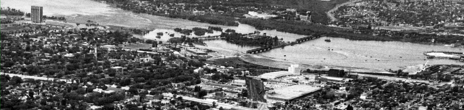
Here’s another pigeon eye view of the median bus lane as it approaches Preston. That may or may not be a pedestrian sidewalk in the median:

(the building on the left with the green stripe is TD Bank CIBC, with the Claridge ICON tower crane on the far side of Preston. Note the cycle tracks have reappeared.)
I question the need for two median bus lanes on the west side of Preston intersection. Provided traffic signaling favours bus movements over general vehicle movements … it should be possible to do away with the EB>NB turn lane and still maintain bus priority. Use the saved space to widen the pedestrian sidewalk along the median to the intersection. Do not even think of obliging all users to access the island only at Trillium crossing.
The pedestrian refuge shown in the median at the Preston crossing (west side) is timid. Leave the crosswalk zone flush with the road asphalt, but pave it in concrete. Then extend the raised island another few feet further east beyond the crosswalk (to meet an imaginary line drawn from the Preston curb line on the north side of the intersection to the Preston curb line on the south as it goes towards Prince of Wales), to force vehicles further away from waiting pedestrians trapped between buses and general vehicle lanes full of cars and trucks. This minor change offers significant subjective safety improvements. Refer to the plan drawing at the top of this story to see how far recessed the medians are to be.
Similarly, the narrow median between the bus lane and WB traffic lanes on the east side of the intersection, should be resumed on the west side of the crosswalk to match the main median. This will improve the angle of vehicles making WB>SB turn movements and keep them off the crosswalk.
On the east side of the Preston intersection, there is a WB>NB turn lane in front of the ICON building. This is shown on the plan drawing, but not on the photoshop illustration. This hasn’t been in use for two years, and won’t be for another two or three while the building is constructed. This demonstrates it is not required. Remove it permanently. Use the space for a raised planter / buffer to the sidewalk and cycle track.
Unless, of course, the objective is to have a high density, high rise, high traffic, unlivable space combination. Busy intersections don’t have to be hellholes.
Similar comments apply to the Booth intersection: extend all four medians into the intersection beyond the crosswalks / crossrides, to encourage vehicles to turn less obliquely and more slowly, and thus approach the crosswalks nearest the receiving lanes at right angles. And, the cycle track merge onto Booth NB is too short, move it another 10-20m along the street.
Richard Eade has these comments on the Sherwood to Preston section:
The removal of one east-bound bus stop between Champagne and Preston makes it less convenient for transit users. To help mitigate that, I would like to see the ‘sidewalk-like’ median strip between Preston and the Trillium stop fully available for pedestrians – but I fear that it will be only a ‘maintenance strip; with $125 Fine signs (the city is undecided if peds will be allowed to walk along the median from the bus stop right to Preston, they may have to all cross only at Trillium).
It might be possible for the O-Train Trillum stop to be moved to the west of the crossing and another stop added east of Preston.
Before we get to the design east of Preston, I must lament: This new configuration of Carling will likely remove any possibility of the annual Ferrari runs along Carling between Preston and Champagne. The nice, unobstructed, three-lane wide roadway was a requirement of the event. Woe is me. Another fun and popular event removed from Ottawa – The city that fun has forsaken.
The double bus-only lane at Preston might look excessive to Eric, but there needs to be a way to trigger a protected (bus only) left turn signal for the bus. I’m sure that OC Transpo will not want the bus to be turning with the other left-turning vehicles.
_____________
Next: from Preston to Bronson
I am a home owner of Champagne Ave South. I am interested in getting more information on this re development. Is any of this available on the city of Ottawa website? is there going to be public consultations?
No more street closure and transit disruption for that annoying and noisy show of penis compensation?
Good.
One key thing they need to address is cycle time lengths. The pedestrian crossing at Carling station has an excruciatingly long wait for a walk sign.
In Kingston, all signalized crosswalks at transit stops are “instant”–when you push the button, the light immediately starts changing.. the only exception is a 25 second “lockout” period after a walk cycle concludes to prevent pedestrians from blocking motor traffic indefinitely. Major roads like Princess and King have these, so there’s no reason why arterial roads can’t have them.
Ottawa needs to follow suit with this crosswalk. An LRT stop needs easy pedestrian access.
What’s the currently planned car lane width here?
I’ll put them into tomorrows story.