
: Ashcroft Canyon … a prototype?")

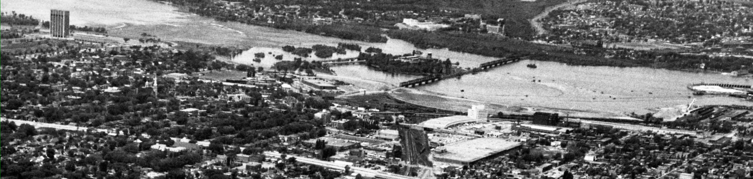
You all recall the big brou-ha-ha when Ashcroft bought the site of Our Lady of the Condos on Richmond Road, just west of Island Park. They already owned the sites on the north side of the street, with several 6+ storey buildings underway or in planning. The agreed with the City to increase the height of the just-completed one on the north side (111 Richmond), and the south side ones are notably higher, as shown in the picture above.
The top floors of these buildings are set back a bit, so the top floors are less noticeable when the viewer is on the sidewalk on the same side of the street. The opposite side-of-the-street top floors are far from invisible.
The buildings were pushed back several feet from the sidewalk/lot line, to create a wider pedestrian experience. But the result to date is bleak. The ‘stepping back’ of the buildings at mid block, the recessed top floors, the varied brick textures and colours (dull, duller, and dismal) don’t succeed in making a thrilling space. Despite variations, they are all designed by the same architect from the same base plan, and it shows. The few trees planted in front of the existing condo don’t look promising:

I do hope there is a large underground area of great topsoil under those pavers so the tree roots and spread and feed and the trees above will grow big and wonderful, with foliage and shade.
Of course, the appearance will be better once the buildings are fully finished, the lights are on, and the two cut-outs or passageways into the Convent grounds are opened up. Active storefronts will help too (please, no giant window appliqués of happy people).
Nonetheless, the “canyon” epithet is not intended as a compliment to fine urban planning. I do wonder if the City planners are looking at this project with satisfaction, or with a “lessons learned” attitude? And if there are lessons, when will they be applied to further projects?
As a perceptive reader, you must have guessed by now that a very similar configuration of buildings is about to be revealed. Coming up next … yet another west side mainstreet intensification plan.
 is Ashcroft Canyon worth replicating?
Further to the “canyon” metaphor, when Eric G and I were riding through there a couple of weeks back on our bikes, physics (distance, wind, background noise from traffic, etc.) required us to shout to hold a conversation. There was a very crisp echo from the hard surfaces of the buildings directly across from each other.
The people who eventually reside in these buildings are going to need some good earplugs for when the pubs let out (or the street festivals).
Indeed.. There are many things to love and hate about Somerset-Wellington-Richmond but I find there is a distinct change in character for the worse when you hit the couple blocks of new condos. They’re sterile and unpleasant in a way that the car lots and old apartment buildings aren’t. Sigh.
Alright. We’re 1/100th of the way towards “Paris-style” density. Snide comments aside, I will withhold judgement until everything is done (and it’s not the middle of winter). However, the massing is what people say they “want” (tolerate?) — how fine-grained should the city’s input into design be?
That’s a good point. If this were the model up the side streets and along the length of Westboro we’d be in Paris territory except with 50x the number of cars (they have few or no parking garages splitting sidewalks and deadening facades) but maybe out of sheer density we’d get the shops, grocers, and public spaces that we deserve. I’m really not sure.
But the developer’s drawings show how beautiful it will be, don’t they?
Reminds me of the wind tunnel that is Laurier Avenue (Bronson to Bank) every time we pass thru that now sad bit of Richmond Road.
I suspect it will not be too long before the canyon extends all the way east to Island Park. The two blocks on the south side are used car lots which appear to have changed hands in the past year. On the north side the collection of buildings appear to be owned by Ashcroft (one is being used as their site office) and the last block before Island Park is another used car dealer which also appears to have changed hands recently.
The “canyon” of course is what this and virtually every community design plan calls for on mainstreets. A similar pattern is being championed by Jennifer Keesmaat in Toronto. This pattern is one way of delivering residential density in relatively low density areas, desirable and vibrant as they often are. If we want to preserve residential streets as low-rise, don’t want high-rises in these neighbourhoods either, and now are opposed to mid-rise buildings on mainstreets – where does the growth go?
Let’s also not forget that this block used to be graced with a 8+ foot concrete sound attenuation wall right at the sidewalk’s edge, so its not like it replaced a lovely block of Westboro, it was a massive gap in the street, and the auto-oriented commercial on the north side wasn’t exactly pedestrian friendly either. Add to that the car uses on all 4 corners of IPD/Richmond Road/Wellington West, the Canadian Bank Note site, and the school yard and you had basically three blocks of dead streetfront to contend with. Once the storefronts are leased and businesses open, and the residents moved in on the south side of the street, we will have a better sense of what this area will really feel like.
As Eric G said, of course they’re sterile – they’re brand new! Character doesn’t come in a box, it has to develop over time. Right now it’s a construction site, a bank branch and a sales centre – obviously not good yet, how could it be?
Sorry, but I’m going to call bull on this one Geoff. Ashcroft Canyon is NOT the sort of development called for in Community Design Plans – not here (Westboro CDP) or East of Island Park (Wellington West CDP – a process I was part of for 3+years) – nor is it the kind of development we should be advocating for anywhere in the City.
The Planning department ignored many aspects of the CDP when they allowed Ashcroft to pack a single unbroken facade-wall of 9 stories (the CDP called for 4-6) along the South side of Richmond. Blocking sunlight, crowding the sidewalk, and obstructing access and views of a beautiful stone heritage building, these are exactly the OPPOSITE of the built form CPDs are meant to encourage. As for the “8-foot sound barrier”, okay that was an eyesore that needed to go. But hidden behind it were beautiful, lush gardens, and the Convent building itself. The least the City’s planners could have done in return for the extra height is insist on breaking up the frontage with a deep public plaza or pocket park.
The battle for the Convent Lands is *mostly* over. And we apparently can’t hope for any help on this from our current Ward leadership. But at least we can hope that future City politicians and planners can clearly see and learn what went very wrong here. And make sure it never happens again.
I am a long-time resident of Westboro (and not a city planner or a developer), but I feel a lot older than my years when I see the former convent wall described as “8’+ concrete sound attenuation” and the former Canadian tire store on richmond road with its adjacent gas station described as “auto-oriented commercial” and the area described as “dead street front.” I know you can’t beat city hall or stop time (I learned that from a former kitchissippi city councillor), but I think Westboro deserves better. CDPs and city plans seem to mean all or nothing at all – depending on who wants to do what!
What is Ottawa’s fixation with setbacks? Is there a single instance, anywhere, of a setback improving the streetscape? I can’t think of any. All they do is deaden and bleaken the space. Enough with the flippin’ setbacks.
Easy: the one at the Lieutenant’s Pump and environs on Elgin. Or the one at Anglican Church on Richmond in Westboro, just west of Churchill. Both of these setbacks break the streetwall but in so doing create usable and welcoming urban spaces.
Setbacks aren’t the universal evil you make them out to be, but their use has to be judicial as well.
The main problems with that stretch of Laurier are the brutalistic buildings towards the western end, and, naturally, the pointless setbacks of some of the buildings which make the street more barren-feeling than it needs to be.
What is Ottawa’s fixation with “wind tunnels”? Any building higher than two storeys, and suddenly the cry is “wind tunnel!” I have yet to experience any of these wind tunnels, except, of course, when it’s windy everywhere else, too.
Blocking sunlight? Good. Streets need to have a shady side, especially in the fetid humid cesspit which is Ottawa in the summer, shade which pointless setbacks take away.
East-west streets will pretty much always have a shady side – the south side. What we don’t get is a sunny side for the winter.
It’s been a couple of years now since the Westboro Station development was built between Roosevelt and Golden. That block is now miserably dark and dreary in winter, especially in the weeks before Christmas. Funnily enough it’s worst on bright sunny days because the shaded gloom of the street contrasts with the brightness of the sky. On such days it’s far more pleasant east of Roosevelt than it is west of it. For a brief few years between the building of the Starbucks-Westboro Pharmacy on the north side and the destruction of the old eclectic mixture on the south side we had actually managed to extend the Westboro feel about a block westwards… but now that’s been effectively lost again.
CBC’s DocZone had a documentary on winter a couple of years back, comparing how various cultures deal with winter. One of the notable things was that the Norwegian cities kept building heights down to 4 stories to minimize both shading and wind tunnelling. Indeed, far from being the mythic phenomenon you make it out to be, they had people out there measuring wind speed at various spots in the city and figuring out how to minimize them.
http://www.cbc.ca/doczone/episodes/life-below-zero
WJM,
the wind can be unbelievable on the corner of Bank and Laurier. I use the bikepath all year and that corner is particularly bad, pretty much every day, no matter what the wind conditions are at other parts, no matter what wind conditions are. Sometimes I have to pedal hard to practically stand still. I used to think that Albert/Bay was bad (also on bike, though didn’t try that in the winter) but this seems to be worse, or I am softer with age.
Yes, their use has to be judicious. Note that both of those examples are from early 20th-century architecture. The contemporary Ottawa mentality is Setback for Setback’s sake. It creates crappy streetscapes. If there’s going to be an ongoing, human use for that set-back space, go for it. Otherwise, keep the streetwall intact and emphasize granularity, not dysfunctional setback fetishism.
I walk that corner pretty well daily during the work week, and at least one day of most weekends. I have never experienced these “particularly bad” wind conditions there, except, as noted, when it’s windy everywhere else.
Not once. Never. Been in Ottawa almost 25 years.
I simply do not view shade as a problem, summer or winter. And since Ottawa, like everywhere else on the surface of the earth, is rotating around the axis of our planet, at some point during the day, even in winter, at least one side of the street will have sun during a portion of the day.
What is Ottawa’s fixation with sunny streets? We need shadier ones, not brutally sun-swept sterility, which we have in overabundance.
Still looking for those “wind tunnels”. Still haven’t found one that is wind-tunnelly when it’s not windy anywhere else.
It would be nice if the architects actually had some original, interesting designs. (Well, maybe they do, but it gets beaten out of them.) Ottawa seems to generally be cursed with visual blandness.
WJM – Sorry I disagree about the wind tunnel on Laurier. Maybe if you only stick near the blocks around Bank st, you don’t feel it, but I lived on Laurier, near Bronson for 5 years. There used to be two houses (I lived in one) and they were the last ones standing before being bought and converted to massive condo towers. I walked to/from Bank everyday to catch the bus and there was a wind tunnel, the most vicious area being on Laurier between Bronson/Lyon. When it was cold and I would have to run to Bank to get out of it.The first spot of respite was in front of the Minto building (plus a safe area to get inside and warm up a little). Maybe the rest of Laurier is fine, but the condo lane from Bronson was not.
Here’s a photo of those houses, taken from the Stonecliffe in the ’80s: https://twitter.com/Centretowner/status/416646483006730240/photo/1
So, it was windy there, when it wasn’t windy anywhere else?
I have never, ever, EVER experienced this in 22 years in Ottawa.
WJM – Isn’t that what makes life so fascinating? I often wondered it myself, how the wind effect was maximized along that route, yet seemed so calm once I reached Bank st.
I have no idea why living on the crest of the hill where Laurier/Bronson meet would create a wind tunnel effect moving down the hill on Laurier towards the lower area of Bank street, between the rows of office towers and condos. Nor do I know why it might start to die off around the relatively flat area of Minto at Lyon. I just know how it was when I walked to and from home for 5 years along there (often taking Glouchester instead because it felt less breezy & warmer!).
Charles A-M – I lived at 574 in the mid-90s. When we left, the house was bulldozed and the last condo built.
Meg: I think you are describing the basic components of an aircraft wing.
First, the air is channelled down the Ottawa River valley. I used to cycle the Champlain Bridge on a daily basis and you could clearly feel these gusts.
This channelled airflow then arrives at Nanny Goat hill and will be travelling at speed as there are no obstructions on the LeBreton Flats.
When it passes over Bronson / Laurier the air is them faced with a dip in the surface geometry. Looked at in profile this would exhibit a shape similar to an aircraft wing. The air either needs to accelerate so as to fill the increased volume found along Laurier east of Bronson. Or the air performs a laminar flow at an elevation above Laurier this will result in a the creation of vortices which will pull the air up from the surface. This action creates a vacuum that pulls more air in, and this results in higher air speeds and greater turbulence in this area. My hunch is that you would find a big volume of air being pulled in from Albert / Bronson and moving diagonally across that open area just to the north of Laurier and contributing to the effect you describe.