

Long-sufferings readers here may recall the unfortunate initial design and build of the portion of Booth going from Albert Street, over the new OTrain Confederation Line, to the Macdonald Parkway. It was justifiable to call this a freeway design. It was as inhospitable as possible for pedestrians and cyclists, despite the location of Pimisi Station at the midpoint.
A “fix” has been in the works for a long time, and the most urgently needed portion is now in place. And more improvements are in the works (read on !)
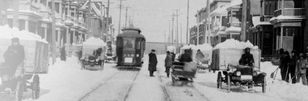
Lets review the new design, which is substantially complete. Here is a photo looking north, towards Gatineau, from Albert Street:

The new raised cycle track offers reasonable separation from motor vehicle traffic. The track follows the line of the curb, which defines a slighter-wider-receiving lane for turning car traffic that then narrows to a less-wide lane dimension than previously provided. This helps calm vehicle traffic, and the wiggle in the track (exaggerated a bit due to the angle of the photo) may calm cycle traffic too. The bus shelters in the foreground are temporary, until Pimisi Station opens.
Where the cycle track goes over concrete, a black coating has been applied to better define the cycle track:

The cycle track passes behind the bus boarding area, while staying on the curb-side of the pedestrian sidewalk. This is the “best practice” design long-proven in Europe, and similar in principle to the track/bus stop interface on our first complete streets (Churchill, Main). However, it is a “first” for Ottawa at a major transit boarding point, and will be the first exposure for many cyclists and transit users.
It will take a while for people to get used to the design. When Pimisi opens, I expect that OC Transpo may supply some “ambassadors” at the station entrance for the first few days to help guide people to the bus stop. This may also be an opportunity for Bike Ottawa to repeat their successful ambassador program that they employed when the Laurier bike track opened.
The city will also monitor how well the design works, to have data on hand when similar designs are proposed elsewhere in the City and for Phase 2 of the LRT.

The bus boarding area is “fenced” from the track to help keep all the users in their “right” places, which is especially important at the crossing points.
The fence shown to the left on the picture below was designed to keep cyclists on the track and off the boarding area. I think it also steers errant pedestrians out to the curb, and there needs to be a similar fence gently directing walkers to the crosswalk:

The crossing points are marked with broad white “zebra” stripes, replacing the zig-zag lines previously used in the city, which no one understood. There are also “shark teeth” triangles painted on the approaching track advising cyclists to yield to pedestrians. The painted triangles are used throughout the city to advise road users to slow down, eg at raised intersections, speed humps, etc.
Only the cyclist-approaching side of the bus boarding zone has fences. The second half of the zone, beyond the pedestrian crossing point, will have heated bus shelters installed in February for those who choose to wait for the bus out by the curb. Waiting in the Pimisi Station forecourt or building is also possible, but is unheated.
Due to the multiple uses for the available space, the fences and some posts are very close to the track. I’d like to see some reflective strips put on those immovable objects.
As the cycle track is elevated, the guard rail along the side of the bridge and viaduct portions of Booth was also raised:

Kudos to the City for employing this planter to help steer users rather than more fencing:

The planter helps soften the bridge structure environment, and reduces the sense of Booth being a freeway or traffic sewer rather than a city street.
As part of the reconstruction and fix, the centre median on Booth was removed from the viaduct portions, but not the bridge itself, where it is integral to the structure. The two-way street portion and the more modest traffic lane widths also help reduce the freeway appearance.
For northbound cycle traffic, the design is similar:


It remains to be seen if the pavement markings are sufficient or if additional not-to-be-noticed signs on posts are installed. It isn’t helped that pavement paint now seems erasable as part of our climate action plans.
There was some initial objection to how the cycle tracks met Albert Street. The design favours cyclists turning east or west on the Albert MUP and left cyclists continuing south on Booth confused.
The current configuration is temporary. Once Albert is given its final curb lines and pavement after the LRT opens and transitway buses are removed (… late 2019? 2020?) the final-configuration intersection should handle all movements quite well:

There will be separated, above-the-curb cycle tracks on both Booth going north, and both directions on Albert. This is the city’s new standard “protected intersection” design which will be used throughout the Albert-Scott corridor and probably elsewhere too. It aims to keep separate pedestrians, cyclists, and vehicular traffic, both while moving and while queuing up at crossing points.
Instead of mixing with motorised traffic in a centre left turn lane, cyclists approach the intersection and do a two stage left turn, crossing on “crossrides” (ie, crosswalk zones for cyclists, beside the ones for pedestrians) in a counterclockwise direction. It’s not complicated in real life, and looks pretty intuitive / natural when built.
Alas, not all of Albert will be final in 2019, and portions of the MUP will remain in use for another few years, so there are some two-way cycle track portions to try to deal with all possible combinations of routes, desires, safety, and attentiveness. It is further complicated by the new Pimisi Station entrance mid-block between Booth and Preston (the former Broad Street right of way) and the lack of marked intersection where Rochester meets Albert (that intersection legally exists, and Rochester will bring cyclist and pedestrian traffic to an “unmarked” intersection. It remains to be seen what pedestrian and cyclist desire lines there will be…).
There are some “winter cyclists” who will have noticed that the new cycle facilities are not being winter maintained:


Q: With all the adjacent space behind the sidewalk, why did city crews choose to pile the snow onto the cycle track?
A: it isn’t (yet) on the city’s winter cycling route clearance list. And there is the question of which group will pay for the winter maintenance.
But city staff are working on it.
The Macdonald parkway intersection
Users of the new cycle track may have noticed that it also ends rather awkwardly at its northern extremity, near Fleet Street (by the Claridge design centre). The curb here is made of asphalt, and is unlikely to last many winters.

Fortunately, it wont have to last long. Starting in February 2019 or April 2019 (depending on who is telling you) there is some needed “infrastructure” and “utility” work going on the extend city services out to Zibi’s project on the islands.
Bad news: As part of this utility work, the street will be dug up.
Good news: Zibi will reinstate the street to the new design, including raised cycle tracks, and a better intersection at the Parkway:

The parkway will have some cycle lanes painted. Again, it is hard to know how “permanent” this is given the NCC’s longer term plan to install cycle tracks/lanes on Wellington, allowing tourists to visit on bicycle, all the major sites, once the STO buses are off. Will that scheme extend all the way to the War Museum?
And the portion of Booth running north of the Parkway towards Gatineau will also be made into a complete street as far as the main turn in point to Zibi on Head Island. After that it is up to Gatineau to approve the Zibi plan, which may also be implemented in 2019. Here’s the portion running by the War Museum:

Zibi may have this installed and open for use by July 1st, 2019, for Canada Day and for Bluesfest.
Quite an improvement in the cycle connection to the SJAM from when I lived near Somerset a few years ago. The challenge then was to find a cycle route from the SJAM to Somerset -Laurier that did not require a steep climb. Hopefully the situtation will improve further with the proposed new Scott-Albert cycle lanes.
These improvements will also be a boon too tourists who wish to cycle from downtown to the War Museum, Chaudiere falls and SJAM west who do not want to take the risks of the current route
With all the painting of roadways, sidewalks and bike lanes will the city still be using the same eco friendly paint that disappears so quickly. Isn’t there a more permant paint solution?
Can the recent ‘fixes’ to the Booth Street flyover be enough to allow us to forgive the transportation planners who designed this folly? I don’t think so, especially when you consider its impact not only on transportation, but the desecration of the historical Aqueduct and nineteenth-century Booth Street Bridge, and that the new Bridge presents a massive physical barrier between the east and west sections of LeBreton Flats, where, one day, people will live. Booth Street should have been maintained and improved at grade, with the LRT below it. But we have the flyover now, and the costs of ‘fixing’ it will only increase as the years go by.
The improvements for cyclists are welcome, although there remain “multiple conflict points.” Would it not have been helpful to change the grade for cyclists, even by a few inches, so that the bike path is below the sidewalk, to help separate cyclists from pedestrians? How does the City propose to prevent transit users from crossing the four lanes of traffic on the Bridge to walk from the bus stop on one side to the LRT entrance on the other? For pedestrians moving in and out of this area, hopefully we’ll be able to avoid the new Bridge altogether, and use the new MUPs to reach Albert Street and points south and west.
As someone who occasionally must drive to and from my home on Lett Street, the right turn from Booth east on to Fleet is always worrisome, because you must cross an ill-defined intersection over a cyclist and pedestrian crossing. And for the drive out of this area of LeBreton Flats, the City has not yet addressed the effect of the prohibition on left turns on to Booth from Fleet and from the SJAM. With 1,600 new residences to be constructed southeast of the Bridge, the majority of whom will drive (according to current plans), will the u-turn on Booth north of the SJAM continue to be permitted? Will the new plans for LeBreton Flats redevelopment include the restoration of the extension of Preston north to the SJAM? However imperfect, both provide solutions for local traffic to the problems created by the construction of the new Booth Street Bridge.